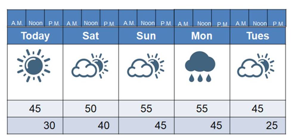
Aside from a chance of rain on Monday, the next 5 days are looking pretty darn good! I may end up having to add some lightning bolts to Monday’s forecast, as it looks like we may have a chance for some thundershowers. Looking beyond Tuesday, high temps look to remain around the mid to upper 40s, with lows near 30. There are no arctic outbreaks in sight.
Yesterday, I mentioned how that snowfall totals were much higher than forecast across western Kentucky and southeast Missouri with Monday’s system. Several folks messaged me and wanted to know if I was going to adjust my snowfall predictions for the plateau. While it was tempting, in the end I decided to stick with the original prediction. I admit, I was nervous. The reason for those higher snowfall totals can be explained by several circumstances, all of which couldn’t have been foreseen with enough accuracy to predict 6-10 inches of snow. Their forecast called for 1-2 inches.
First of all, the front slowed down a lot. The snow should have started here shortly after sunset Sunday but it didn’t get her until Monday morning. Plus, a bit of energy in the jet stream moved over the front, which caused snowfall to pick up intensity. The faster the winds blow aloft, the faster the air here at the surface gets pulled upward. Upward-moving air rises, cools, and condenses into precipitation. That really helped enhance their snowfall. Some isolated locations had up to 12 inches of snow!
Could that have happened here? Of course it could. I recall once when I was a kid when we were supposed to get 1-2″ with a system like this and we ended up with 6″ of snow. These northern systems can offer surprises. You also have to factor in that with these dry snows one inch of rain could equal up to 20 inches of snow. That makes a big difference too. Normally, one inch of rain equals about 10 inches of snow. Winter weather forecasting can be quite the challenge around here! We have that huge Gulf of Mexico just to our south, and all of kinds of access to cold air to our north. If those two meet, we get walloped. Foreseeing such collisions is where the challenge lies! But, challenge accepted, Ma Nature, challenge accepted! ha
Starting this weekend with meteorlogistmark.com I will be doing things a bit differently. I will have the 5-day outlook just as it is but that will be followed by a brief summary of the weather. That will then be followed by a more in-depth discussion section, for those who want to know the details behind the forecast. I will start doing this with TapTalk on Monday. I may have a mother who says my posts are a bit “wordy” and that a summary would be nice (haha). I agree, Mom.
You all have a great day and a great weekend! The weather will finally be nice enough again to get out and enjoy it!