Main Threats
No major threats in sight
Summary
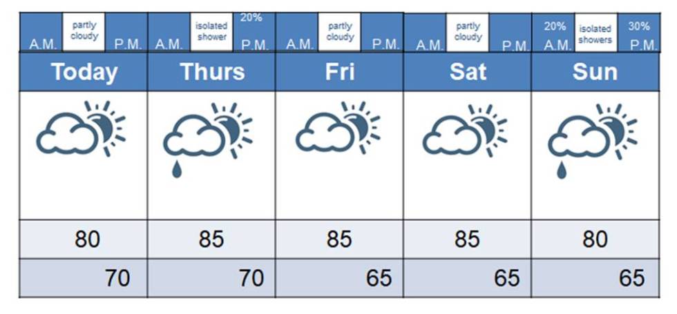
We will continue to see pleasant conditions today, with partly cloudy skies. By tomorrow, a weak disturbance may bring us a passing shower, but it’s nothing to cancel any outdoor plans over. We go right back into a pleasant pattern for Friday and Saturday, though it will be a bit warm in the afternoons.
By Sunday, we may see some influence from Florence. That just all depends on the track. This is an every-changing situation, so stay tuned. I have much more on this in the tropical section below.
Tropics
It would be the understatement of the year to say that all eyes are on the tropics this morning. If there’s any good news, it’s that Florence did not reach category 5 status last night. Instead, she focused more on attaining her powerful cat 4 status and expanding in size. That just means that her influence will be felt at a much farther distance.
Hurricane force extend out 70 miles from the center. That means a 140-mile swatch of hurricane damage. The tropical storm force winds extend out 175 miles from the center. This makes Florence a nearly 400-mile wide storm.
The storm continues on a westward track and we are now certain that she will make landfall along the Carolina coast. Evacuations are in full throttle. This will be the worst storm to hit the Carolinas in decades. Should Florence come ashore in North Carolina with winds greater than 130 mph, she will be the most powerful land-falling hurricane in North Caroline history (as far as records go).
The storm is being steered by a strong area of high pressure to its north. This steering will persist through today and tomorrow. After that, the steering currents drop to nearly nothing. That is the greatest problem facing forecasters. Unfortunately, that steering drops off just as the hurricane reaches the coastline. That means there’s nothing strong enough to really shove it inland. So, what will it do? That’s the million dollar question that millions of people in the Carolinas are needing an answer to.
As for Virginia….things look better for them this morning. Yesterday, the storm was expected to pull a bit north after landfall and drop 15-20+ inches of rain on that state. This morning, those rainfall totals are looking about half as bad. That’s still a problem for them, but not as big of a problem as it looked like yesterday. The greater threat may be storm surge along the coast, especially if Florence stalls out and just keeps shoving water inland.
So, what if a cat 4 hurricane just hugs the coast? That is the worst case scenario. Imagine if Katrina had stalled out over the Gulf Coast. That is a scenario no one wants to see.
The new path poses a challenge for those of us in Tennessee, too. Now, the impacts of the remnants may bring us some rain and gusty winds next week. We’ll just have to watch things and see.
Look at how enormous this storm is now! Also, notice the remnants may push into southeast TN early next week.

In other tropical news….
We still have a disturbance in the Gulf that may develop into a storm before striking Texas. That system is looking more disorganized this morning, so hopefully it won’t develop.
We now have a disturbance right behind Florence, though Florence may consume that one.
We still have another disturbance northeast of Florence. It bears watching.
Then, there’s Tropical Storm Isaac, who is still heading into the Caribbean. He needs to be watched.
Then, there’s Hurricane Helene. Thankfully, she’s curving out to sea. I know, it’s rude of her not to visit but we won’t hold it against her. We have enough company already!
That’s probably about as busy as you’ll ever see the hurricane map. I’m not sure we can fit anyone else in! Everything but Helene is moving westward in some way.

We’ll skip the records section, as I have a lot going on this morning (as you can imagine).
Keep in mind that weatherTAP is free for everyone through the weekend. Just use “florence” as the username and password. That’s it! It’s just a little something we want to do to try to keep everyone safe and informed about Florence.
You all have a great day and don’t forget to keep the millions of people in the path of this storm in your thoughts and prayers. Keep them close to your heart. They’re about to face some really, really tough times. If you’re here on the plateau, take a moment and be thankful for what you have today and for this beautiful weather we have outside. We should have no complaints here today, folks.
I snapped this while stuck in traffic on Hwy 127 this morning. I started to get aggravated until I looked up. And then I thought about all the people stuck in evacuation traffic. We should have no complaints today, folks.
