I know many of you are a bit shell-shocked with the thought of the recent storms, and that is perfectly understandable. After seeing what severe weather has already done in Tennessee this year, everyone is right to be concerned. In fact, it’s good to have a healthy appreciation for what the weather can do. We just don’t want that to evolve into an irrational fear.
The key to staying calm is twofold; education and preparation. Educate yourself on the weather. For instance, the peak of our severe weather season is March, April and May. Pay a little more attention to the weather in those months. Prepare for the weather before it hits. A little preparation can go a very long way in keeping you calm and safe. Reading/Following my blog can also be very helpful.
Number 1
Check the convective weather outlooks daily this time of year.
Those are available on weatherTAP’s RadarLab. Or, you can go to the Storm Prediction Center’s website at https://www.spc.noaa.gov/products/outlook/. Is the plateau highlighted in any sort of risk? If so, how serious is the threat? There are five levels, including marginal, slight, enhanced, moderate, and high. They are all color coded. The threat is lowest at marginal and highest at, well, high. Easy to remember that, right? So, by checking the threat level each day from the experts (the best of the best), you already have a heads up. Our most common threat levels are marginal, slight and enhanced. The threat is getting very serious when moderate risks are issued. High risks are rare and suggest extremely dangerous weather is possible/likely. I will always let you know in this blog if we are at any of these risk levels.

Number 2
Know the difference between a WATCH and a WARNING
Now, let’s say the threat is near and a WATCH is issued for our area. Do you know what that means? A WATCH means that we are watching the radar and keeping an eye out for any bad storms. A WARNING means bad weather is here. Some people remember this by thinking of cupcakes. A watch means the ingredients are there, a warning means the ingredients have come together. Anyone else hungry now?

I also like to tell the kids at schools that a WATCH is when you’re watching the oven and anxiously waiting on the cakes to get done. A WARNING is when the cakes are done and you warn your family that they better stay away from your cakes! ha
Number 3
Understand polygon warnings.
A whole lot of panic can be avoided if everyone understood what a polygon warning is. The National Weather Service does NOT issue warnings by county. They used to but they no longer do. Your app may, but the NWS does not. If a tornado warning is issued for Crossville and the storm is moving east, I have no reason to take cover if I live in Mayland or anywhere north, south, or west of Crossville. A polygon warning would show that. It would also show that Crab Orchard would be in the path of the storm and those folks would need to take cover. WeatherTAP’s RadarLab shows polygon warnings. Get rid of any apps that do not utilize this polygon warning product.
Please note: Many of you said your phones did not go off during our last tornado here in Cumberland County. That may be because your phone app uses the polygon warning system. That is great! I just hope your phone not sounding an alarm doesn’t mean the warning isn’t working on your phone. Check your settings.
In the example below, hundreds of thousands people are unnecessarily warned about severe weather with the old county-based warnings. With polygon warnings, that number is cut drastically!
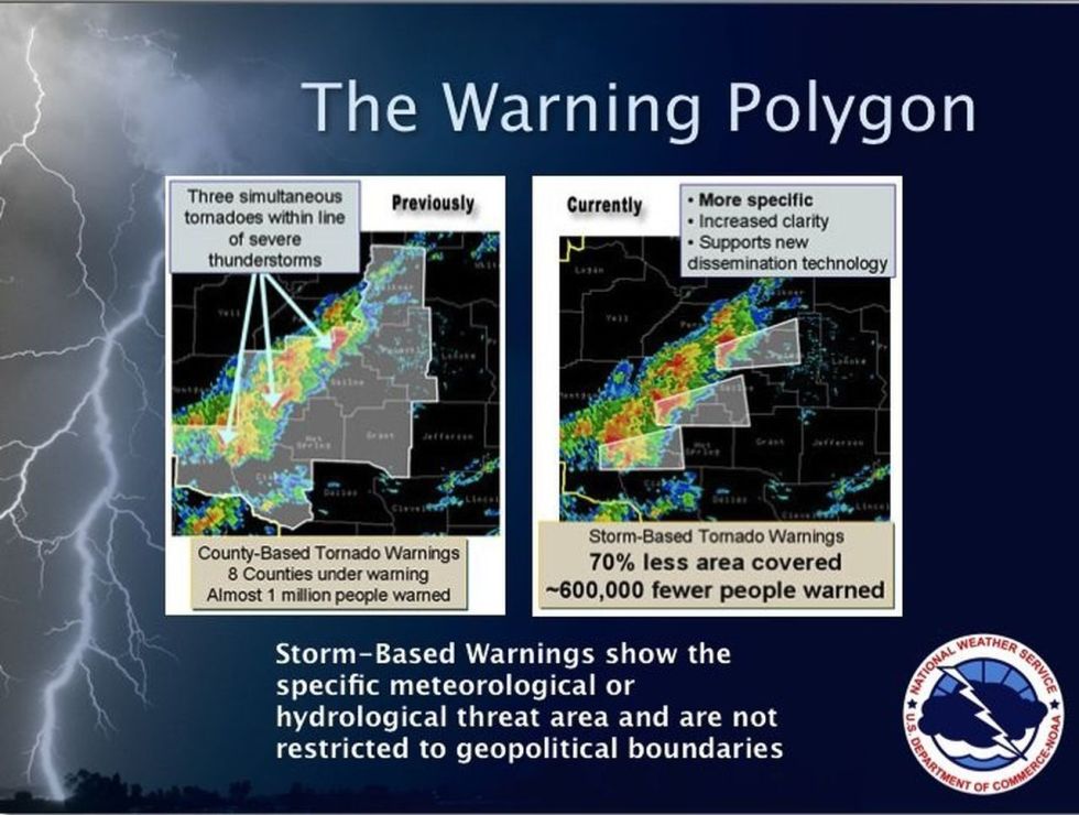
In the example below, only the folks in the red polygon should be taking cover. I should note that the NWS is very generous about who is in the polygon. If you are not in the polygon you do not need to take cover. The only exception would be if the storm is moving in your direction and you know the polygon could be extended into your neighborhood in time. For example, in the warning polygon below (shaded in red) I’m taking cover if I am anywhere within that red-shaded area. The storm is moving toward Mount Juliet (as you can tell from the way it is pointing). If I live east of Mount Juliet I’m seriously figuring out where I’ll take cover if this polygon is extended eastward.

Number 4
Learn to read radar (at least the basics)
Green is good, yellow is worse, and red is bad. If you see a radar image and the “red” is coming your way, you know the bad stuff is also headed your way. Why? Because the darker colors on radar represent heavier precipitation, whether that be rain or hail. Winds always increase as you go up into the atmosphere. That heavier rain can push down those winds and cause you to have damaging wind gusts. It just depends on how fast the winds are above us as to how much wind the rain can push down.
In the image below, the red regions on the radar are the heaviest precip and the green areas are the lightest precip. Yellow is moderate rainfall. By the way, that red-circled area is what we call a “mesoscale discussion.” Those are issued by the NWS to give you more information about storms or to give you a heads up that a watch is being planned for that area. RadarLab has that and that information is available at the Storm Prediction Center website.

In the most serious tornado warnings, a “hook echo” will appear and show you the tornado’s location. The area near the hook is the region where the tornado is located. Keep in mind, not all tornadoes produce a hook signature on radar and not all hooks are easy to spot. The absence of precipitation within the hook is caused by the rising motion of air being so strong that precip can’t fall to the ground. That’s a strong updraft!

Number 5
Know where you live
Just because this is number 5 does NOT make it less important. Where do you live? Most people have no idea how to answer that question. What is your community called? Are you at the north end of the county, the south end? In Cumberland County, where are you in relation to Crossville? Are you north of town, east of town, etc.? Know where you live so that when a warning is issued you know how real the threat is for your area.
I live in Rinnie. If a tornado warning is issued for southern Cumberland County and the storm is moving east (toward Knoxville) I’m not taking cover. There’s no need too.
Get online and Google a map of you county and search your address. Make sure you know where you live. That may sound silly, but just because you know how to drive to your house, doesn’t mean you know where you are on a map.
Number 6
Know what to do
I saved the best for last.
Lowest level of your house, away from windows, with as many walls as you can get between you and the outside. Don’t wait until a warning is issued at 2:00 a.m. to try to figure out where that safe place is in your home.
The winds of a tornado increase dramatically with height. Get off the second floor. The winds will be much, much higher up there. Get low and get flat.
Abandon the mobile home or trailer during a tornado warning. Just get out of it. You have a better chance getting under the porch than you do staying inside (seriously).
Wear your bicycle helmets. Most serious storm injuries are to the head. Protect that noggin’! Use pillows if you don’t have a helmet (but helmets are best!).
Keep your shoes on. People end up with terrible injuries to their feet by walking on broken glass, etc. Just keep your shoes on when you take cover.
Don’t mess with those windows. Cracking the windows waste time and doesn’t make a difference.
If the lights go out do you have a flashlight handy, or are you stumbling in the dark and using the lightning to find the way? Don’t be unprepared. Keep a flash light in your nightstand drawer. Have batteries and battery powered radios, etc.
Are your cell phones charged up? Charge them up. Charge up the tablets too. Gather whatever the kids (and you!) can play with to distract them from the storm as it’s happening.
Communication is often a mess after severe weather. Try to have multiple ways of reaching friends and loved ones who will be at work, etc. when severe weather is expected. Cell phones may go down, the power may be out, and the internet may fail. Keep that in mind.
If caught in your car you are in a very unfortunate position. However, if you buckle up and lie down in the seat you stand a chance. You’ve basically strapped yourself inside a tin can and are hoping the winds down flip you around. Please check the weather before you head out and avoid this awful situation.
Number 7
Have multiple sources of information
Have a weather radio but don’t rely on it solely. Chances are it’s all you’ll need, but have another source, just in case. There are numerous weather apps. Find one and download it. Just keep in mind that apps do fail sometimes.
Set your weather radios to your home county and those counties to your north, south, and west. We rarely get any bad weather from the east, so you’re likely alright to not worry about those counties. But, definitely have the counties that border your north, west, and south.
For reference, I’ve provided a map of the Upper Cumberlands below.

Finally, I know this blog post won’t dissolve all of your concerns but it sure could go a long way it making those concerns….well, easier to bear. These are just some of the most common things I get asked about. Just be prepared.
And please know that severe weather like we had last week in Putnam County is so incredibly rare. We hadn’t seen a tornado like that around here since 1974! Folks, we are so very fortunate for that fact because there are folks out on the plains that would love to have that kind of statistic.
Also know that most tornadoes, especially around here, are survivable by getting in the middle of your house. Most of the time interior walls are left standing. That’s something to be thankful for.
I certainly hope this has helped and I hope that you feel free to ask me if you have any questions that are not answered in the blog.
You all have a great evening and let’s all stay safe and sound this spring severe weather season.
[Remember, to follow the blog just find the “follow” button in the lower right corner of the screen. That will get you emailed updates when a new blog is published. Most phones will then notify you that a new email is in your inbox, much like when you get a text message.]

I am trying to find a weather app that used polygon alerts for my Android phone. What app do you recommend?
Hi Mary. It looks like MyWarn uses the polygon warnings. http://www.mywarn.com/?page_id=123