At a Glance
48-Hour Weather

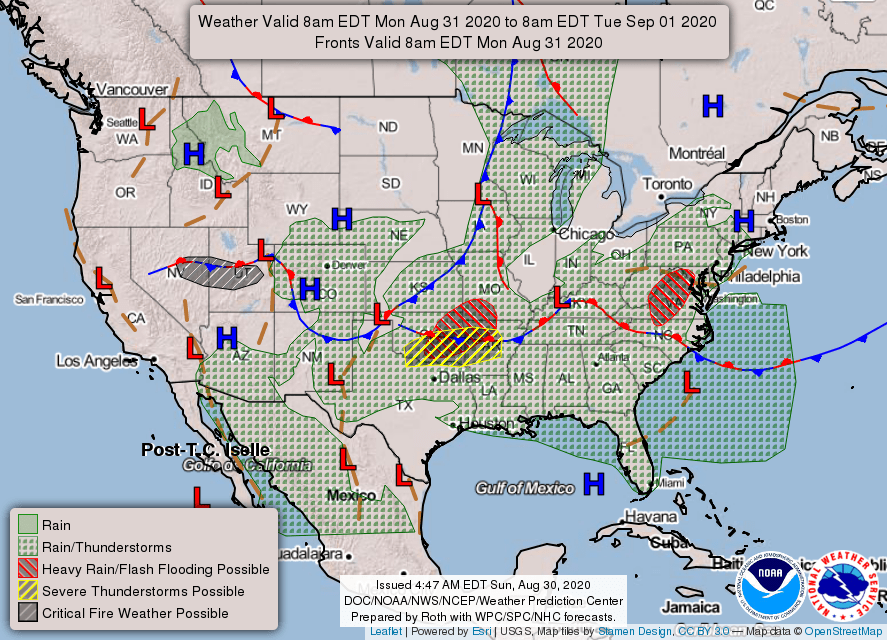
Threats
Any storm that develops today, tonight, or tomorrow could contain very gusty winds (locally damaging?), heavy downpours of rain, and frequent lightning. Widespread severe weather is not expected, but any storm could become locally severe.
Storms Tuesday through Friday will become more isolated, but they could also be on the strong side.
Baldwin’s Severe Weather Concern

Baldwin’s 7-Day forecast

Daily Forecast
Sunday – Monday: Rain and storms. Some of the storms could be strong. Heavy rainfall is possible.
Tuesday – Wednesday: Scattered showers and storms, especially in the afternoon/evening. Otherwise, mostly cloudy skies.
Thursday: Warm and humid, with a chance for an afternoon/evening shower or storm.
Friday: Scattered showers and storms with a frontal passage, mainly in the afternoon/evening.
Saturday: Partly cloudy and pleasant.
Baldwin’s Hay Day Forecast
Those of you trying to cut some fall hay are going to have a tough time of it this week. Disturbances and frontal boundaries will spark off numerous showers and storms this week in our very humid airmass. A cold front will hopefully slide through Friday and hopefully give us a drier weekend. Unfortunately, extended outlooks show more wet weather, especially with the possibility of tropical storms, as the tropics become very active once again.

Almanac

Yesterday’s National High and Low Temperature
High: 114 at Death Valley, Stovepipe Wells, and Ocotillo Wells, California
Low: 29 at Klamath Marsh, Oregon
Tropics
Now, we have FOUR areas to monitor. The National Hurricane Center is now most concerned about an area of low pressure moving off the Southeast Coast. It will likely become the next named storm, Nana, as it moves out to sea and away from the US. Three more areas are being watched for possible development this week across the southern Atlantic.

Today’s Wx Hazards Across the Nation
Heavy downpours could produce local flash flooding across parts of the Midsouth, including our area, for today. That threat is also found across parts of Arizona. Meanwhile, severe storms threaten eastern South Dakota and eastern Nebraska.

Tomorrow’s Wx Hazards Across the Nation
Heavy rainfall threatens Virginia and Maryland, as well as portions of the southern plains. That southern plains threat also comes with the risk for some severe storms. Farther west, where it’s much hotter and drier, a wildfire danger can be found across parts of Nevada and Utah.
Tuesday’s Wx Hazards Across the Nation
Unsettled weather continues across much of the country, with the heaviest rainfall falling across parts of the southern plains. Meanwhile, a tropical storm may be developing off the Carolina Coast.

On This Day
On this day in 2005 the remnants of Hurricane Katrina moved into Middle Tennessee. Nashville measures 1.97″ of rainfall. Clarksville records 2.07 inches, while Crossville receives 0.99 inches. Winds gust as high as 40 miles an hour at all three locations.
Sunday Story
Cat 5
The most powerful hurricanes are given a category five ranking. Only four of these storms have ever made landfall in the US, since record-keeping began. Two of those storms hit in the month of August.
Hurricane Camille struck the Gulf Coast in August of 1969 with a ferocity unlike anything the Mississippi Gulf Coast had ever experienced. Entire coastal communities were swept clean away. Maximum sustained winds were nearly 200 mph at landfall!
Camille tracked north across Mississippi and West Tennessee, and then moved east across Kentucky and into the mountains of West Virginia. Flash flooding turned mountain streams into raging rivers. The storm killed 143 people on the Gulf Coast and another 153 people in flooding in West Virginia.
Camille reminded us that a hurricane’s effects can have far-reaching, devastating effects. More people were killed in West Virginia than were killed on the Gulf Coast.
Another powerful August hurricane was Andrew in 1992. That storm devastated southern Florida, narrowly missing downtown Miami with its 160 mph winds. That storm strengthened slightly while it was inland, drawing energy from the hot and humid marshland. This is quite rare for tropical systems, as they normally weaken once they move inland.
Andrew was the first named storm of that season and was the most powerful hurricane of that entire season. The rest of that season was quiet, but the devastation of Andrew was all it took to make that whole season a bad one to remember. It only takes one storm.
Andrew crossed southern Florida and ended up in the Gulf of Mexico. The storm eventually moved north into Tennessee, bringing heavy rainfall and gusty winds across the plateau.
We are right to worry about coastal communities during hurricane season, but we mustn’t forget the impacts that can be felt far inland, too.

You all have a great day!
