I want to welcome the many new followers I picked up over the past week! I sure am glad to have you following along. Each Sunday, the blog is a bit different. At the bottom of this blog you’ll find a Sunday Story. This is a story that I write weekly for the Fentress Courier and Livingston Enterprise. I then publish it here in the blog, after it has ran in the papers. I hope you enjoy!
Headlines
Rain moves in late tonight
A nice warming trend Tuesday and Wednesday
Turning colder to end the week
Meteorologist Mark’s Wx Vlog
48-Hour WX

Five-Day Forecast

Daily Forecast Summary
Today: Mostly sunny. Showers develop after midnight. Becoming breezy during the day.
Monday: Mainly morning rain. Otherwise, mostly cloudy. Breezy. Temps falling in the afternoon into the 30s by sunset.
Tuesday: Mostly cloudy and warmer.
Wednesday: Mostly sunny, clouds increase toward evening. Chance of showers after midnight.
Thursday: A chance for showers. Colder.
48-Hour Precip Forecast

Meteorologist Mark’s Wx Concerns

Meteorologist Mark’s Wx Discussion
On This Day in Wx History
1918 – A spectacular chinook wind at Granville, North Dakota, caused the temperature to soar from a morning low of 33 degrees below zero to an afternoon high of 50 degrees above zero! That’s difference of 83 degrees! A chinook wind is a downsloping wind that warms as it descends the eastern slopes of the Rockies.
Almanac

26 Days until Spring!

Yesterday’s National Temperature Extremes
High: 83° at El Centro, California
Low: -24° at both Ely & Brimson, Minnesota
Today’s National Wx Hazards
A mixed bag of wintry precip will fall across the southern Appalachians tonight. That mixed precip can also be found in an area stretching from Kansas and Nebraska to Ohio. Farther north, that mixed precip turns to snow. Snow can also be found across the Pacific Northwest once again.
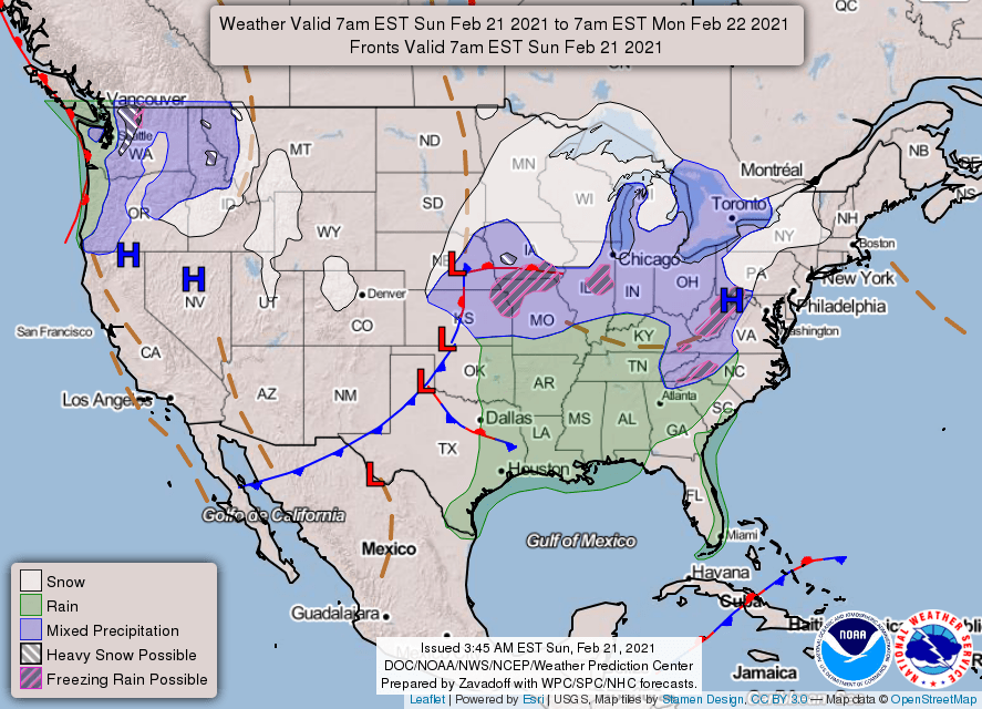
Tomorrow’s National Wx Hazards
Icing could be a problem for western North Carolina and Virginia on Monday. That ice may even affect areas around our Nation’s capitol. Accumulating snow will slow travel across parts of both New England and the Great Lakes. More snow, some of it heavy, will fall across the northern Rockies.

Sunday Story
In my experience as a meteorologist for the Cumberland Plateau, there are two things that concern people most around our area. The first is tornadoes and the second is ice storms.
Both are certainly worthy of our fears. Ice storms bring tremendous hardship to folks and make travel virtually impossible. Ice storms cover such a large area, wreaking havoc for a great number of people.
Thankfully, tornadoes are very localized disasters, though they are quite destructive and life threatening. Many of us associate tornadoes with a threat to both our lives and homes.
As we approach the end of February, it’s hard not to recall one of the worst natural disasters to ever strike the plateau. The ice storm of 2015 brought destruction the likes of which the plateau had never seen. Significant ice accumulations combined with gusty winds to create damage that was described by the governor as looking like the damage of an EF-2 tornado across the entire plateau.
As we approach and make our way through spring, we’ll cross many tornado anniversaries for the plateau. The first of which will be the 2012 Leap Day tornado that struck Rinnie, claiming 2 lives shortly after crossing Highway 127.
The newest one will be the one-year anniversary of the Cookeville tornado, coming up on March 3. That was the deadliest tornado to ever strike Putnam County, claiming the lives of 18 people and destroying numerous homes.
April 3, 1974 is the anniversary of the super tornado outbreak that ravaged the Upper Cumberlands. Numerous lives were lost and millions of dollars in property damages were accrued from those storms. The most powerful tornadoes to ever strike the Upper Cumberlands hit that day, remarkably with F-4 tornadoes in Overton, Putnam, and Fentress Counties.
Although the scenery of the plateau is always gorgeous, our skies sure can turn ugly.
