MM News
I still have a few seats left in the Meteorologist Mark kid’s class for tomorrow evening! Class begins at 4:00 and is free. The topic is fire tornadoes and we’ll even be making a fire tornado outside! Registration is required and that short form can be found at https://docs.google.com/forms/d/e/1FAIpQLSdohiaR1Slm0CYWnwhQSi8w0LyY51aAO91OJpffFSabw3FOqQ/viewform. See you there! Class is capped at 20 students.
Weather Headlines
A pleasant week
Low humidity will feel nice this week
Watching a system in the Gulf and on the Atlantic Coast (the tropics are active!)
Meteorologist Mark’s Wx Vlog
Seven-Day Forecast

Daily Forecast
Today: Mostly sunny and hot. Lower humidity will make it feel much better than days past.
Tuesday – Wednesday: Lots of sunshine and lower humidity will make it feel quite nice!
Thursday: Humidity begins to increase a bit. We remain dry and sunny.
Friday: Humidity increases a bit more. We remain mostly dunny and dry.
Saturday – Sunday: Mostly cloudy, with scattered showers and thunderstorms.
Hay Weather Forecast

Forecast Discussion
Some of you may be wondering why I had to increase today’s high temperature to 85 degrees. That’s hot!
The thing to keep in mind is that drier air is moving in from the north. Dry air heats up very efficiently, but it doesn’t feel nearly as hot as humid air. Then, at night the drier air cools more efficiently than humid air. Moisture holds on to heat and keeps air warmer. It’s like in the desert. You have scorching hot afternoons but the humidity is really low, making it feel less oppressive. Then, at night it gets downright chilly because the dry air can’t hold on to the heat very well.
Think about our humid days. The high temperature may just get to 80-85 degrees but it feels so much hotter when that humidity is high. Then, at night the moisture in the air retains the heat, giving little relief.
Let’s enjoy the lower humidity this week. We all know …..it will be back!
And with that, I must cue the Arnold.

Meteorologist Mark’s Wx Concerns

Almanac for Yesterday

Tropics
My goodness, how quickly things have escalated! We now nearly have a tropical storm off the coast of North Carolina! That system is moving northeast and away from the U.S. The system of most interest to us is the one in the Gulf of Mexico. That system is expected to become a tropical storm this week, as it slowly moves north and northeast. It will likely increase our rain chances this weekend and early next week, though heavy rainfall does not look likely at this time. The heaviest rain should stay to our south. However, this is many days away and things could change, so stay tuned. At the very least, if you have travel plans to the Gulf Coast the end of this week to the weekend, you need to pay close attention.
Then, we have another area of low pressure off the coast of Africa. We’ll track that as it moves westward this week.
Is this June or August? It’s too early to be this crazy in the tropics!

Sun & The Moon

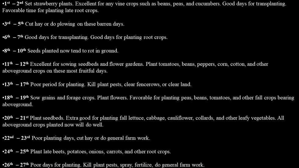
Planting by the Moon in June
On This Day in Wx History
1903 – The Heppner Disaster occurred in Oregon. A cloudburst in the hills sent a flood down Willow Creek, and a twenty foot wall of water swept away a third of the town in minutes, killing 236 residents and causing 100 million dollars damage. A cloudburst occurs when a storm rapidly weakens, sending much of its water falling to the earth.
Yesterday’s National Temperature Extremes
High: 116° at Death Valley, California
Low: 24° at Peter Sinks, Utah
Monday Sun Day
With a diameter of 109 times the size the Earth, the Sun makes a really big sphere! You could fit 1.3 million Earths inside the Sun. Or you could flatten out 11,990 Earths to cover the surface of the Sun. That’s big, but there are some much bigger stars out there. For example, the biggest star that we know of would almost reach Saturn if it were placed inside the Solar System! Space….it’s so big!
Today’s Tennessee Weather
It’s another hot day in Tennessee, but I have some good news! The humidity will be dropping through the day! That will make it feel much more comfortable than the hot and humid days we’ve seen over the past week. So, while highs will be around 90 for many of us, the drier air will make those warm temperatures feel much less oppressive.

Tonight’s Tennessee Weather
As drier air continues to filter in from the north, overnight lows will fall into the low to mid 60s. Starry skies will make for some excellent night skywatching!

Tomorrow’s Tennessee Weather
The drier arrives Monday and the slightly cooler air arrives to go with it on Tuesday. Though temps warm into the low to mid 80s for most, that northerly breeze and low humidity level will make it feel quite nice!

Drought Monitor
The drought monitor is updated each Thursday.

Weather SnapShots
I took this picture of some mammatus clouds yesterday evening. These clouds are rounded patches that hang beneath a cloud (often associated with thunderstorms). Mammatus are a rare example of sinking air that condenses. Normally, sinking air dries out. These are able to form because ice crystals are falling from the cloud. Before the sinking air can dry, the ice crystals melt and form water droplets, which then evaporate as they sink. The process forms these pouches of clouds. The lower the water droplets get before evaporating, the lower these pouches will hang.

NASA Nerdology
Stunning panorama of astronaut Harrison Schmitt exploring the surface of the Moon during Apollo 17! (Credit: NASA)
