Posted on Leave a comment

A beautiful weekend is on the way

Picture8

SUMMARY

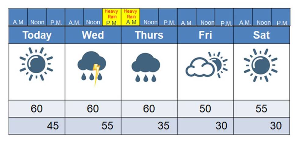
We have a lot of rain coming, folks, but hang in there! The weekend is looking cool and dry. As of this morning, it looks like the heaviest rain will fall across southern Middle TN, but we could still see 2-3 inches across the plateau, especially for folks south of I-40. For those of you north of I-40, amounts should be less, with 1-2 inches when you get up to Jamestown and communities north of there. Just be aware that we could have some flooding, especially in areas that typically flood. The most severe flooding looks to occur along the TN counties that border Alabama. More than half a foot of rain may fall down there tonight. With soils already saturated, that could be a real problem for those folks. Thank goodness we live on this mountain!

I will mention that it could be quite breezy Thursday afternoon and evening. With this saturated ground, we’ll need to be mindful of shallow-rooted trees sitting in saturated soils.

The weekend continues to look nice. It will be cool, especially compared to the warmth we’ve had, but the sun will be shining. I can’t remember the last time we had a weekend that was sunny from the beginning to the end. Those cooler nights are just what we need to slow the budding of the trees and flowers down. It’s still just February, after all.

DISCUSSION

Yesterday I made a boo-boo and thought that the severe weather awareness week topic was tornadoes. It wasn’t . That’s today. I guess with the excitement of my birthday I got carried away (ha). There will be statewide tornado drills this morning at 9:30, so if you hear those sirens going off that’s what it’s for.

Yesterday’s topic was lightning, so that’s what we’ll talk about today. About 50 people a year are killed by lightning. If you hear thunder roar, go indoors! Even if you see dark clouds gathering, you should move indoors. We suspect that some lightning fatalities are from people getting struck by the first lightning strike and didn’t have the opportunity to hear the warning sound of thunder. Lightning strikes are up to 50,000 degrees hot, which is hotter than the surface of the sun. One bolt has enough electricity to power a small community for at least a day. No one has ever survived a direct strike by such a force of nature. No one. Ever. Many folks think they’ve survived a strike, because it hit so close to them. Who could blame them? If I had something that powerful hit within a few yards of me I’d probably get a glimpse of Jesus too!

Stay away from taller objects. Lightning is electricity. Air is an insulator. Therefore, in order for lightning to make it to the earth, it wants to find the shortest path to have to cut through that inhibiting air. That being said, we have seen lightning strike the shortest objects too, it’s just less common. And lightning can strike the same place twice, as well. The Empire State Building in New York as been struck multiple times in the same storm. Seek shelter in a building, away from windows. Cars do protect you, but they do so by the metal sheath that directs the bolt away in all directions. Contrary to popular myth, the rubber tires offer no protection. If in a car, make sure you’re not in contact with anything that conducts electricity, or else you’ll get zapped.

Here on the plateau, folks injured by lightning are usually working construction sites outside, playing golf, fishing, or horseback riding. All three of these activities put folks right in the danger zone for lightning. If you’re outside a lot, it might be wise to invest in a pocket lightning detector. It looks like a beeper and has an alert for when lightning is close enough to be a threat. I have one for storm chasing. Lightning is the greatest threat associated with storm chasing. It about drives us nuts! ha

The good news with this storm system is that there shouldn’t be much lightning at all (if any!). There’s just not enough instability for robust thunderstorms. We will, however, have some heavy rainfall and that is always something to be aware of.

You all have the best day! I fly out for the Space Coast this evening and I am so excited! I’ll have lots of pics and videos, for sure! And check out the story about me in yesterday’s Crossville Chronicle when you get a chance! It’s on the second or third page.

See you from the Space Coast!!!!

Posted on Leave a comment

Afternoon update on tomorrow’s rainfall

Good afternoon, everyone. We’ve managed to reach a high temp of 61 degrees at 2:30 this afternoon. I hope you’re enjoying all this nice sunshine.

The NWS has issued a flood watch for all of Middle TN and the Cumberland Plateau. The watch goes into effect Wednesday afternoon and will remain in effect through Thursday morning. A map showing projected rainfalls was also released. As this rain falls on saturated soils, we could be looking at some flooding issues.

image3

Flood watches are the dark green-shaded counties.

WARN_REG_SOUTHEAST-SVRff

Also, I wanted to remind you that there will be another online spotter class Thursday evening at 6:00 p.m.  These classes are very informative and interesting, and I encourage anyone with an interest in weather to take one of these courses.

image16

You all have a great evening! Get out and enjoy this beautiful weather before this next rain system moves in! And yes, next weekend is still looking very nice.

Posted on Leave a comment

A Beautiful Day ……for a BIRTHDAY BOY!!!

Picture7

SUMMARY

What I can’t figure out is why this isn’t a red-letter day? It’s Meteorologist Mark’s birthday, after all! I’m always surprised to see the mail running and banks open on the 27th. Mystery of mysteries….

As for our weather, well, it’s certainly no mystery. It’s absolutely beautiful…and calm…and quiet… Did I order this for my birthday? Absolutely not! What a ridiculous question.  But, it is what it is. I guess we could use some sunshine, though? Our next system is getting fired up to our west today, and that will come in here on us tomorrow. Heavy rainfall is expected, so be aware of that, especially Wednesday night. On Thursday, the rain tapers off and we’ll be all set for a really nice weekend, folks. Can you imagine a nice weekend? How long has it been?

DISCUSSION

Remember, this is severe weather awareness week. Today ‘s topic from the NWS is tornadoes. Yes, my favorite weather topic was saved for today!

Keep in mind, when a tornado warning is issued you need to put as many walls between you and the storm as you possibly can. If you have a basement, that’s a great place to be. Just be mindful that you still need protection, as sometimes homes collapse into basements. Seek shelter in a far corner, and protect yourself from falling debris. If in a vehicle, get into a safer structure. Cars can become unsurvivable missiles. Trailers and mobile homes are just as bad. Abandon them and seek sturdy shelter.  DO NOT waste time cracking windows open. The “pressure will blow your house up” myth is a dangerous myth that has probably gotten people hurt. No one’s house is so air tight that pressure can’t change adequately enough. Plus, you have bigger problems if the tornado is that close to you. Never seek shelter at an underpass on the interstate or wherever you might find one. Winds increase dramatically with height in a tornado (get as low as you can go), so putting yourself up in the rafters of an underpass sets you up for disaster. Plus, wind tends to funnel under the overpass, creating a wind tunnel effect that will suck you out (we’ve seen it happen too many times).

March, April and May are the peak of our tornado season, though they can occur any time of the year. Most of our tornadoes around the plateau are weak, but heaven knows we’ve had our share of strong ones. The most recent one was the Leap Day tornado (Feb. 29, 2012) that hit Rinnie, claiming 2 lives. That tornado hit about a mile from my mom and dad (too close!). Before that, we had the violent EF-3 that tore through Tansi in November of 2002, claiming 4 lives. Notice that was November. Fall is our secondary tornado season.

The most powerful tornadoes to ever hit the plateau occurred on April 3, 1974 during a super outbreak of tornadoes that hit the eastern US. An F-4 tore through Jamestown, killing 7, while another F-4 hit near Cookeville that evening. Also, another F-4 hit near Byrdstown.  We had an F-3 hit Plateau Rd. that night and it was the last significant tornado of the outbreak. In all, 148 tornadoes hit 13 states that evening.

I don’t think I ever fully appreciated the terror and power in a tornado until I finally caught my first one in Jackson, TN on Feb. 5, 2008. The half-mile wide EF-4 had 175 mph winds as it raced by me going  65 mph. I didn’t chase for several years after that, but I finally got my nerve back in time to go with some friends out to Oklahoma for a chase in 2013. We caught a little bitty one out there and nearly had another come down right on top of us (always remember to look up! ha). We narrowly missed an EF-5 that was about 20 miles to our north. The destruction from that thing was something I still can’t describe.

Hopefully this tornado season will be easy on us. This early spring weather is concerning, but a lot more has to come together to get big storms. There may be some thunderstorms around here tomorrow night, but it looks like they will stay below severe limits. It’s the heavy rainfall that will be of concern.

And then there’s that pretty weekend! I’ll believe it when I see it! ha

And don’t forget, I fly out to the Space Coast tomorrow evening to see my first rocket launch at Kennedy Space Center Thursday evening! I’m so excited to see the GOES-S satellite launched into space! I’ll have MUCH more on that as we get to Thursday.

What a birthday week, right?!

You all have a great day and don’t forget that today is METEOROLOGIST MARK’S BIRTHDAY!!!! The gifs people are using to wish me happy birthday with on Facebook are absolutely hilarious. You need to check them out asap! You’d think I was into the weather or something…..

39e416ed430e4f60ec055277e95a101d


Posted on Leave a comment

Online spotter class tonight and update on Wednesday’s rainfall

For those of you who are interested, there’s another online spotter class being given tonight at 6:00 pm. Here’s the link to register:

https://register.gotowebinar.com/register/2218875326588822274

The class takes about 1.5 hours.

The NWS Nashville just released a special weather statement that suggests they are considering flood watches for Wednesday that may include us. Models show a large swath of 2-4 inch rain amounts, with isolated higher amounts, from Wednesday morning to Thursday evening. The models do not agree, however, on exactly where this swath of heavy rainfall will set up, with locations varying from a swath across southern TN to a swath across southern KY.  I’ll have a full update in the morning!

This particular model has that swath of heaviest rainfall across the southern TN border, but the placement of this rainfall varies with each model run, as well as between different models.

Picture5

Enjoy this sunshine this evening! We’ll have it for one more day before the rain spigot gets turned on again.