Friday Funny

At a Glance
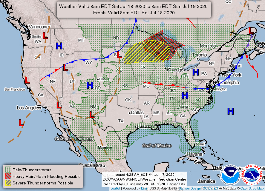
48-Hour Weather

Threats
The primary threat over the next several days will be the heat and humidity. Drink lots of water, stay in the shade/air conditioning, especially during the heat of the afternoon hours.
Any storm that develops will be capable of producing deadly cloud-to-ground lightning, torrential rainfall, and gusty winds that could even be locally severe.
Baldwin’s Severe Weather Concern

Baldwin’s 7-Day forecast

Daily Forecast
Today: Hot and humid. A chance for an afternoon shower or storm.
Saturday – Tuesday: Very hot and humid, with chances for showers and storms each day, especially in the afternoons/evenings.
Wednesday – Thursday: Continued hot and humid, but with slightly better shower and storm chances, mainly in the afternoon/evening.
Baldwin’s Hay Day Forecast
Rain chances continue to trend downward in the coming days. It’s looking hot, humid, and mostly dry for us through Monday. I can’t rule out an afternoon shower or storm, but those chances are only at about 30% through Monday. By Tuesday, afternoon/evening rain chances may tick up to the 40-50% category. I’ll keep you posted!

Almanac

Yesterday’s National High and Low Temperature
High: 118 at both Death Valley and Stovepipe Wells, California
Low: 31 at Peter Sinks, Utah
Tropics
No activity is expected over the next five days.
Today’s
Wx Hazards Across the Nation
A very significant severe weather threat exist across the northern plains today. All modes of severe weather are possible. Wind gusts to 100 mph are possible in the strongest storms associated with a squall line later today. Flooding rainfall is also possible.

Tomorrow’s
Wx Hazards Across the Nation
The severe weather outbreak of today spreads eastward tomorrow. Again, all modes of severe weather are possible, including significant straight-line winds. Flooding is also a concern again on Saturday.
Sunday’s
Wx Hazards Across the Nation
As of now, it appears Sunday will be a much quieter day across the nation.

Records
Sometimes, air near the surface of the earth is so hot and dry that rain evaporates as it falls into it. This happens a lot in desert regions. It may be humid enough in the atmosphere for storms, but the air nearest the surface may be hot and dry enough to evaporate rain that is falling. Precipitation that evaporates before hitting the ground is called virga.
This is exactly what happened on this day in 1941 across parts of Washington state. It is quite unusual for the air to be that dry in that part of the country but that’s what happened. Thunderstorms developed and, while the rain evaporated before hitting the ground, nothing stopped the lightning from reaching the ground. This scenario occurs quite often in the mountains out west and can set lots of wild fires during the fire season.
With Washington, at least 598 wild fires were set by the storms on this day in 1941! A prolonged drought had dried the landscape to a crisp, then came these storms with no rain. What a disaster.
Long Range Outlook
Hot and wet conditions look to prevail through at least the 26th of July.
Temperature

Precipitation

Weather Shot
This is a picture of Comet Neowise over the skies of Colorado, with a wildfire in the lower left of the screen. Photo by Chip Redmond (@wx_chip)

NASA Nerdology
The first images from ESA/NASA’s Solar Orbiter are now available to the public, including the closest pictures ever taken of the Sun. The orbiter launched in February and made it’s first close pass of the sun in June.
“These unprecedented pictures of the Sun are the closest we have ever obtained,” said Holly Gilbert, NASA project scientist for the mission at NASA’s Goddard Space Flight Center in Greenbelt, Maryland. “These amazing images will help scientists piece together the Sun’s atmospheric layers, which is important for understanding how it drives space weather near the Earth and throughout the solar system.”
“We didn’t expect such great results so early,” said Daniel Müller, ESA’s Solar Orbiter project scientist. “These images show that Solar Orbiter is off to an excellent start.”

You all have a great day!