A goal without a plan is just a wish.
At a Glance
48-Hour Weather
Threats
Any stronger storm today and tomorrow could produce torrential rainfall. Be careful if you’re out driving and end up under one of these storms. There is also the risk for a damaging wind gust.
Baldwin’s Severe Weather Concern

Baldwin’s 7-Day forecast

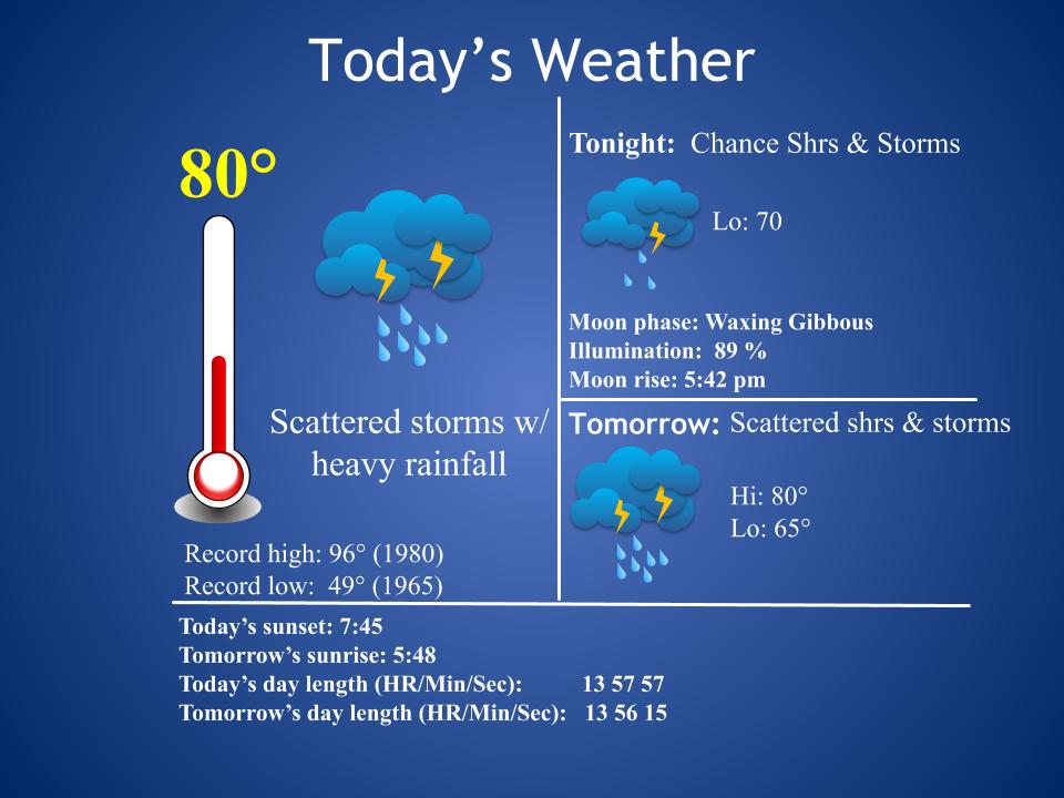
Daily Forecast
Today and Tomorrow: Scattered showers and storms. Some storms will produce torrential rainfall.
Sunday – Thursday: Partly cloudy, with a chance for a mainly afternoon/evening shower or storm. Pleasant overnight temps.
Baldwin’s Hay Day Forecast
Today and tomorrow are the worst of the next seven day days. Scattered showers and storms will make outside work difficult. From Sunday to Thursday, it looks like we will only be dodging a slight chance for an afternoon shower or storm.

Almanac

Yesterday’s National High and Low Temperature
High: 122 at Death Valley, California
Low: 31 at Grand Lake, Colorado
Tropics
Isaias became a hurricane yesterday evening. Winds are now at 80 mph. The storm is expected to reach a maximum intensity of 100 mph just off the Florida coast. The current track forecast has the storm coming perilously close to the Florida coast and possibly making landfall in the Carolinas. The National Hurricane Center emphasizes that both the track and intensity of Isaias are uncertain at this point.

And we have two more areas of concern to watch in the coming days. The tropics are certainly becoming very, very active! We’ve never seen a hurricane season so active, so early in the year (since records have been kept).

Today’s
Wx Hazards Across the Nation
The threat for flash flooding can be found across parts of the Midsouth, which includes our own area. You’ll notice Hurricane Isaias near Cuba.

Tomorrow’s
Wx Hazards Across the Nation
Heavy rainfall threatens the Oho Valley, while Hurricane Isaias tracks toward the US.

Sunday’s
Wx Hazards Across the Nation
On it’s current track, Hurricane Isaias is expected to skirt the coast of Florida on Sunday, as it tracks northward.

Records
When I was in grad school I studied flash flooding. Today is the anniversary of one of the more intriguing case studies I looked at.
On this day in 1976 a stationary thunderstorm produced ten inches (maybe more) of rain over the narrow Thompson River Canyon in northeastern Colorado. The water funneled through the canyon, reaching depths of over 20 feet. The wall of water left a 25-mile path of destruction down the canyon from Estes Park to Loveland. The flood caught campers off-guard and washed away bridges and roads. The damage was extensive. The flash flood killed 156 people.
Today, sirens are in place to warn of flash flooding. For many caught by this flash flood, they were so far away from the storm they couldn’t even hear the thunder.
Long Range Outlook
Cooler and drier weather continue to look likely in the extended outlook for the middle and end of next week.
Temperature

Precipitation

Weather Shot
I snapped this pic yesterday evening. It’s a bear, right? Maybe a cow? You see it, right? lol

NASA Nerdology
The rocket launch that carried Perseverance to space yesterday can be seen on satellite! Notice the smoke plume. How cool is that?
You all have a great day!