“Words of wisdom are spoken by children at least as often as scientists.”
At a Glance
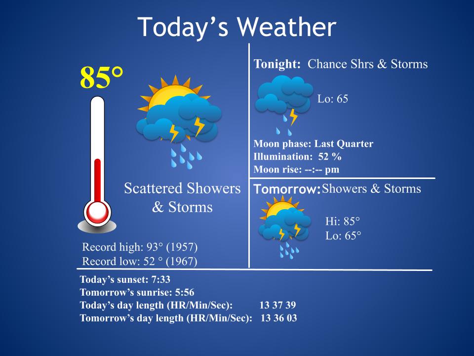
48-Hour Weather
Threats
Any storm this week will be capable of a damaging wind gust, deadly cloud-to-ground lightning, and torrential rainfall. Be mindful of this if you have any outdoor plans this week.
Baldwin’s Severe Weather Concern
Widespread severe weather is not expected. However, any storm could become locally severe.

Baldwin’s 7-Day forecast

Daily Forecast
Today: A chance for some mainly afternoon/evening showers and storms.
Wednesday – Saturday: Scattered showers and storms. Some storms could contain heavy rainfall and gusty winds.
Sunday – Monday: We should return to a more afternoon/evening shower and storm chance.
Baldwin’s Hay Day Forecast
This is still looking like a rough hay weather week. Things look a bit better by Sunday and Monday, but even that could change. Guidance is strongly suggesting that the extended outlook beyond Monday will trend drier and cooler. I’ll keep you posted.

Almanac

Yesterday’s National High and Low Temperature
High: 121 at Death Valley, California
Low: 28 at Grand Lake, Colorado
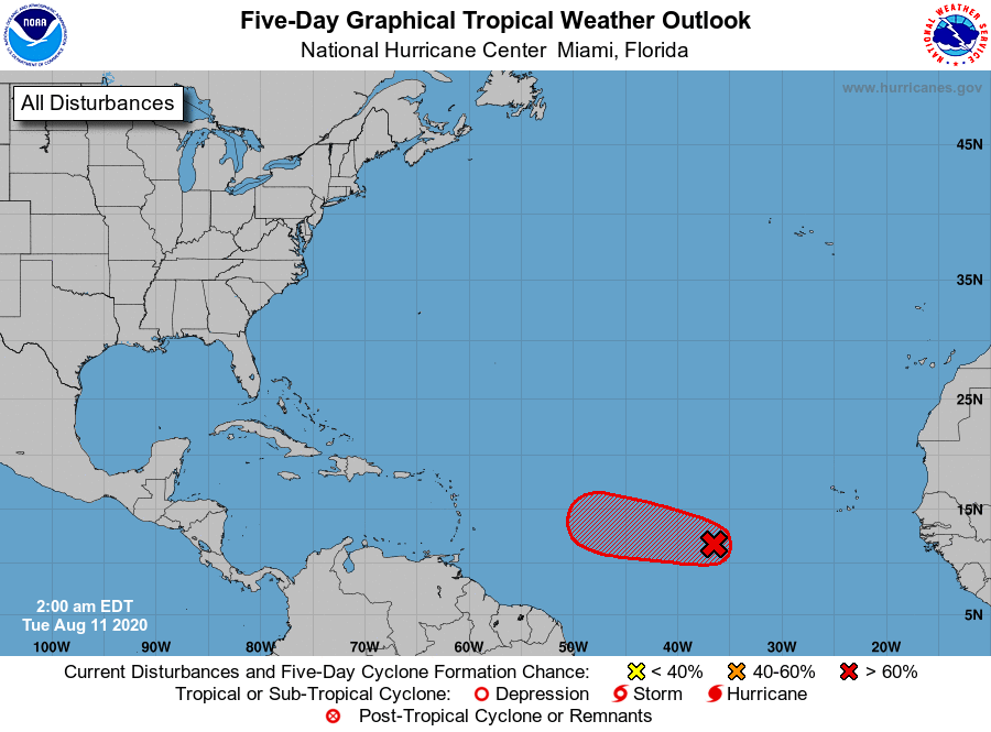
Tropics
It’s looking more and more likely that we’ll have Josephine in the Atlantic sooner than later. It now has a 70% chance of developing. The system continues to organize and I’ll be tracking it, as it makes its way across the Atlantic this week.
Today’s
Wx Hazards Across the Nation
Severe storms threaten parts of western Nebraska and South Dakota. All modes of severe weather are possible. You’ll notice a hurricane in the Pacific. That system is packing winds of 90 mph this morning and is very slowly moving out to sea.

Tomorrow’s
Wx Hazards Across the Nation
More severe storms will threaten North Dakota. Hotter and drier conditions will bring a high wildfire danger to parts of Washington and Oregon. Hurricane Elida continues to spin in the Pacific.

Thursday’s
Wx Hazards Across the Nation
More storms can be found across the northern plains. It’s been a rough summer for those folks! Meanwhile, Elida weakens to a tropical storm in the Pacific.
Records
On this day in 1998 a lightning strike killed a man working out in his tobacco field just northeast of Livingston. Two other workers were injured.
Long Range Outlook
An usual long-range outlook places our region in below normal temperatures and normal rainfall. Normal highs this time of year are around 84 degrees, with lows in the lower 50s. Dare I say we could have overnight lows in the 40s between the 16th and the 20th? I just might dare….
Temperature

Precipitation

Weather Shot
This is remarkable video of the big wind storm (aka derecho) that tore through eastern Iowa yesterday afternoon. The line of storms trekked for hundreds of miles, producing damaging winds (up to 112 mph) and wrecking havoc.
NASA Nerdology
Did you know that the GOES satellites use the moon for calibration? This image from GOES-17 on March 6, 2020, shows the moon rising over the northeast edge of Earth. Both GOES-16 and GOES-17 scan the moon regularly to help calibrate the visible channels on the satellites’ imager. The moon is a very stable and predictable target with no atmosphere.
GOES-16 watches the eastern US and Atlantic, while GOES 17 watches the western US and Pacific.
However, normal processing of the satellite data removes all data beyond the edge of Earth. Special data processing is required to get moon images like this.
Seriously, how cool is that shot?! Dare I frame it?……
Learn more about how satellite data becomes imagery at https://go.usa.gov/xdH2W

You all have a great day!
Persieds tonight!
Sure is! I was afraid clouds would interfere but skies may cooperate, after all! I’ll make a post a bit later.