Posted on Leave a comment

Meteorologist Mark’s Wx Blog for Wed., Dec. 30th

Headlines 

A windy Wednesday

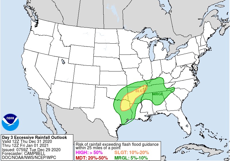
A wet end to 2020 & a wet start to 2021 (1-2 inches of rain expected)

Unsettled weather through the weekend

Meteorologist Mark’s Vlog in a Flash

48-Hour WX

Seven-Day Forecast

Daily Forecast Summary

Today: Increasing clouds and windy. Showers developing overnight.

Thursday: Mostly cloudy, with scattered rain showers likely. Mild.

New Years Day: Rain likely. Windy. Very mild temperatures.

Saturday: Partly to mostly cloudy, with a slight chance for a shower, mainly in the afternoon/evening.

Sunday: Chance of showers. Cooler.

Monday – Tuesday: Mostly sunny & pleasant.

Threats

Strong winds are expected both today, ahead of our storm system, and Friday, behind the storm system. Wind gusts to 30+ mph are possible across the plateau each of those days.

The heavy rainfall threat continues to shift westward. While localized, minor flooding is still possible with heavier downpours, widespread problems are not expected. Rainfall amounts should stay in the 1-2 inch category. That’s still a good soaking rain but not one that causes major problems.

On This Day in Wx History

1955 – Anchorage, Alaska reported an all-time record snow depth of 47 inches.

Almanac

Data is finally starting to come back!

Yesterday’s National Temperature Extremes

High: 88° at Zapata & Rio Grande Village, Texas 

Low: -38° at Peter Sinks, Utah

Today’s National Wx Hazards

An active weather day! Flooding rains will threaten eastern Texas and western Arkansas. A narrow swath of freezing rain will extend from northern Texas to southern Indiana. A narrow swath of heavy snow can be found just north of that. Meanwhile, more freezing rain and snow threaten New England and the Great Lakes region, while another storm system moves into the Pacific Northwest with more mountain snows and valley rains.

Tomorrow’s National Wx Hazards

Freezing rain expands across the southern plains and Midwest. What a mess of a day for those folks! Farther south, flooding rainfall threatens the Arklatex region. Farther west, a storm system brings more snow to the Rockies.

 Weather Shots

As clouds stick with us through tomorrow, yesterday likely held the final sunset of 2020. It did not disappoint! I took this picture in the fields behind the house yesterday evening. It was probably the best sunset I have ever seen. I guess we can say 2020 finally did something right. (ha)

NASA Nerdology 

As I was taking sunset pictures, I looked behind me and saw that huge, nearly Full Moon, rising! It looked so big! A beautiful sunset in front of me and a beautiful moonrise behind me. It was awesome!

You all have a great day!

Please be sure and follow this site by finding that “Follow” button in the lower right corner of your screen. Thank you!

Please feel free to “Follow” me on Social Media!

Facebook @meteorologistmark

Twitter @meteo_mark

Instagram @MeteorologistMark

Posted on 2 Comments

Meteorologist Mark’s Wx Blog for Tues., Dec. 29th

Headlines 

Nicest day of the week is today

A very wet Thursday & Friday in store for us

Cooler and drier for the weekend

Meteorologist Mark’s Vlog in a Flash

48-Hour WX

Seven-Day Forecast

Daily Forecast Summary

Today: Mostly sunny and pleasant. Get outside!

Wednesday: Clouds thicken up and winds pick up. Showers develop overnight.

Thursday: Rain. Heavy rainfall is possible.

Friday: Rain tapers off to showers by afternoon. Heavy rainfall is possible once again, especially in the morning.

Saturday: Partly to mostly cloudy. Cooler.

Sunday – Monday: Mostly sunny and mild.

Threats

Gusty winds are expected on Wednesday. Some of the winds could top 40 mph. A wind advisory will likely be issued by the NWS in Nashville. Secure any outdoor objects. Gusty winds are possible once again on Friday, with gusts to 30 mph possible.

Heavy rainfall is possible Thursday & Friday. This could lead to some minor localized flooding issues. Rainfall amounts of 1-2 inches should be common across the plateau, with isolated locations picking up as much as an inch more. Models have shifted the heaviest rainfall to our west, across western Middle TN and West TN. If you have travel plans in that direction be aware of this.

The Weather Prediction Center has issued an outlook for a marginal risk for flooding across Middle TN for Thursday and Thursday night.

On This Day in Wx History

1894 – A severe freeze hit Florida, destroying fruit and causing considerable damage to trees.

Almanac

This data remains unavailable.

Yesterday’s National Temperature Extremes

High: 87° at Zapata, Texas 

Low: -28° at Peter Sinks, Utah

Today’s National Wx Hazards

Freezing rain threatens areas from the Oklahoma Panhandle to southern Michigan. What a mess of a day for all those folks. Heavy snow will threaten eastern Iowa and southern Wisconsin. Snow will also fall from the Four Corners region to the central plains and Upper Midwest. Quite the storm! A new storm system moving into the Pacific Northwest will bring mountain snows and valley rains.

Tomorrow’s National Wx Hazards

Another messy day for a lot of folks. Freezing rain threatens an area from southwest Missouri to New England. Higher elevations of New England will see that rain fall as snow. More snow will fall across the Great Lakes region, as well as across the mountains of the Pacific Northwest. Flooding rainfall will threaten parts of eastern Texas to western Arkansas.

 Weather Shots

This amazing photo of the moonrise was taken yesterday evening over a farm near Lynden, Washington. Photo by Randy Small (@RandySmall). How beautiful is that?

NASA Nerdology 

How wild is this? Meteorite ALH 84001 was found in Antarctica in 1984. Analysis found that the rock came from Mars, having been ejected from the planet after an asteroid impact! I bet that was a wild ride! If only this rock could talk…..

You all have a great day!

Please be sure and follow this site by finding that “Follow” button in the lower right corner of your screen. Thank you!

Please feel free to “Follow” me on Social Media!

Facebook @meteorologistmark

Twitter @meteo_mark

Instagram @MeteorologistMark

Posted on Leave a comment

Meteorologist Mark’s Wx Blog for Mon., Dec. 28

Headlines 

A sunny, nice Tuesday is coming

A big rain maker arrives by Thursday (2-3+ inches of rain)

A very wet New Years Eve is expected

Meteorologist Mark’s Vlog in a Flash

48-Hour WX

Seven-Day Forecast

Daily Forecast Summary

Today: After some morning light showers, skies should stay mostly cloudy the rest of the day.

Tuesday: Mostly sunny. Enjoy that sunshine!

Wednesday: Winds pick up and clouds increase ahead of our next storm system. Scattered showers develop overnight.

Thursday: Rain, heavy at times. A rumble of thunder is also possible. Rain continues overnight. Localized flooding is possible.

Friday: Morning rain, followed by mostly cloudy skies. Windy.

Saturday: Partly to mostly cloudy skies. Chilly.

Sunday: Mostly sunny and warmer.

Threats

Heavy rainfall is looking likely for Thursday and Thursday night. Rainfall amounts of 2-3 inches may be common across the plateau, with isolated locations measuring as much as 4 inches of rainfall. This could lead to some localized flooding issues. I’ll keep an eye on this potentially flooding situation.

The image below is from The Weather Prediction Center, showing estimated rainfall totals for this upcoming storm system for Thursday. Notice that the Cumberland Plateau is right in the middle of the 2-4 inches of rain swath.

Otherwise, neither severe storms nor wintry weather are expected over the next seven days.

On This Day in Wx History

1894- A cold snap brings record low temperatures to the Midstate. Nashville’s high struggles to reach 10 degrees, after a low temperature of 3 degrees. Brrrrr

Almanac

Station data remains unavailable.

Yesterday’s National Temperature Extremes

High: 86° at Kingsville, Falcon Lake, & Pharr, Texas 

Low: -7° at Gunnison, Colorado

Today’s National Wx Hazards

Wintry weather will impact parts of New England with freezing rain and snow, depending on the elevation. More snow flakes are accumulating across the Great Lakes region. A new storm system will bring accumulating snow to the central plains, stretching westward to California’s Sierra Nevada Mountains.

Tomorrow’s National Wx Hazards

Yikes! Freezing rain will bring ice storm conditions to an area of real estate stretching from the Panhandle region of Oklahoma and Texas, northeastward to Chicago and Detroit. North of that, heavy snow will fall across the Front Range of the Rockies and across much of the central plains and Upper Midwest.

 Weather Shots

South Carolina’s Lynn Wheeler took this photo of a nearly Full Moon shrouded in high clouds at Pawleys Island, South Carolina this morning. What a beautiful shot!

NASA Nerdology 

On his 43rd day, Astronaut Victor Glover (@AstroVicGlover) continues the work of his 6-month stay aboard ISS, he has the record for number of days in space held by African American astronauts. Records are meant to be broken! Congrats on his accomplishments!

You all have a great day!

Please be sure and follow this site by finding that “Follow” button in the lower right corner of your screen. Thank you!

Please feel free to “Follow” me on Social Media!

Facebook @meteorologistmark

Twitter @meteo_mark

Instagram @MeteorologistMark

Posted on Leave a comment

Ring around the Moon

Anytime we have a storm system approaching, the upper levels of the atmosphere typically moisten up first. That leads to those high, thin Cirrus clouds you see in the sky. You may have noticed them this evening with the sunset. It sure was a beautiful sunset! I took this picture of it.

Those same kinds of Cirrus clouds are now making for a ring around the Moon. Even without that ring, the night sky is so beautiful, lit up by a Moon that is nearing Full-Moon stage. In fact, if you thought New Years celebrations might already be a bit crazy this year, there’s also a Full Moon that night! ha

A ring around the Moon often precedes rain and that’s just what we have in tonight’s forecast. It won’t amount to much and some of you may not see a thing. It’s just some scattered showers that will be around the plateau. That rain chance is just 30%.

The ring around the Moon always forms a 22-degree arc around the Moon. As light passes through the ice crystals of the Cirrus clouds, it gets bent at 22 degrees. That leads to a 22-degree arc of light around the Moon. Pretty neat stuff, right?

So, go out and look up! There’s a bit of a breeze, so take a jacket. And you might ponder the idea that someday we’ll have people on that big rock in the sky again. They’ll be at the center of that ring of light and that will make it all the more inspiring!