Be sure to follow the blog and get updates sent to your inbox! Just find that “follow” button in the lower right corner of your screen. Thank you!
Friday Funny

Headlines
A wintry mix is possible areawide tonight (Watch for “black ice”)
A significant winter storm looks likely by Monday (Ice and snow)
Watching the end of next week for another winter storm
Meteorologist Mark’s Wx Vlog
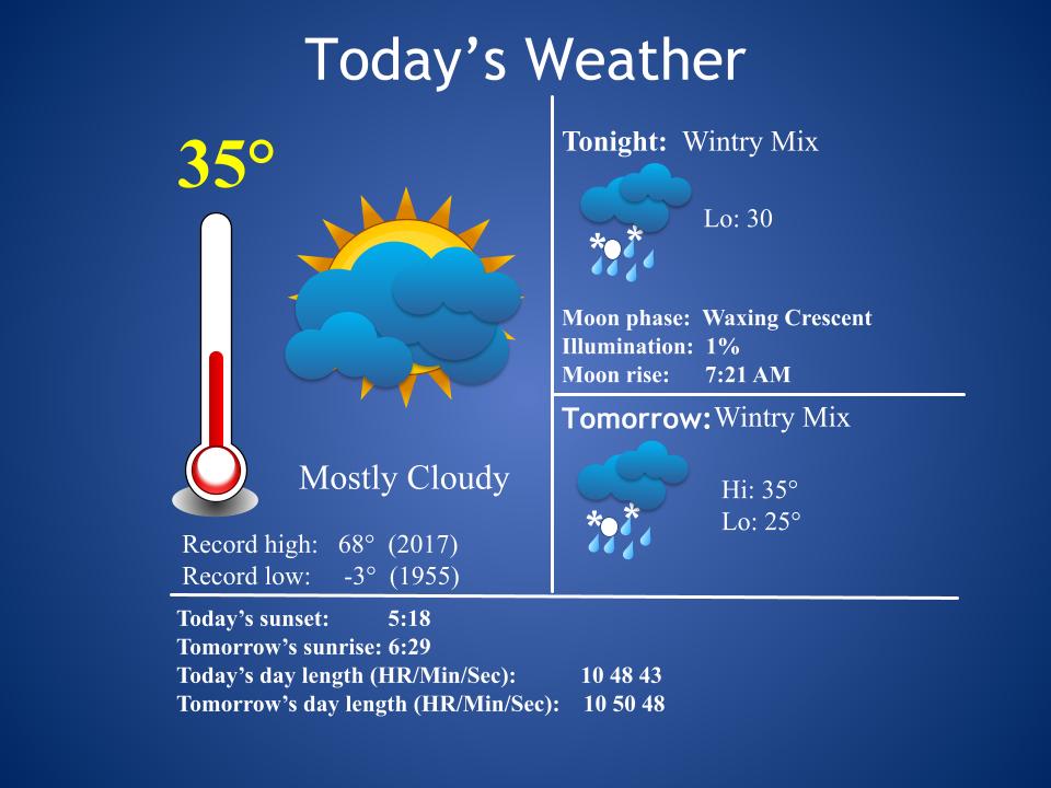
48-Hour WX
Five-Day Forecast

Daily Forecast Summary
Today: Mostly cloudy. A wintry mix develops overnight. Roads could become hazardous.
Saturday: A wintry mix of freezing rain, sleet, and rain. Roads could be hazardous.
Sunday: Mostly cloudy, with freezing rain developing overnight.
Monday: A wintry mix of freezing rain and sleet, gradually transitioning to snow. Accumulations are likely and could be significant.
Tuesday: A slight chance of snow. Additional light accumulation is possible.
48-Hour Precip Forecast

Meteorologist Mark’s Wx Concerns
Impacts from tonight and tomorrow’s system should be primarily to roadways, especially bridges and overpasses. Please drive with care. Precip should hold off until after 9:00 pm tonight. I’ll update that later today.

I’ve added a new graphic to give you an idea of the impacts we might expect from ice. As I’ve said before, I expect impacts to roadways tonight, especially bridges and overpasses. Trees and powerlines should be alright for this round.

This is the much more serious system. This winter storm has the potential to be one of the more severe winter storms we’ve seen in some time. We should expect and prepare for very impactful conditions.

If forecast trends continue, as they have for several days now, we can expect very high impacts from Monday’s winter storm.

Meteorologist Mark’s Wx Discussion
Valentine’s Day weather doesn’t look to show us much love this year…not much love at all.
First of all, tonight’s event continues to look light. That precip will continue into the day Saturday, with travel the most touch-n-go of situations to deal with. I think trees and powerlines will be alright. There is still the possibility that we could rise just above freezing, but I’m becoming less optimistic about that.
Then, the big deal arrives later Sunday night and into Monday. Freezing rain looks to be the dominant precip type and it could accumulate enough to cause significant issues across the region. Prepare for plans to be altered for the first two days of next week. The ice may transition to snow, as it moves out, and that snow could accumulate, as well. Quite the winter storm! Hopefully, we’ll get just enough ice to not be a disaster, followed by just enough snow to not be a disaster, and we’ll get through this better than expected. I’ve seen that happen before here and it can certainly happen again.
Then, we get a break on Wednesday. That break looks short-lived, as another winter storm comes barreling out of the Gulf for Thursday. Right now, that looks like a snow event, but stay tuned. There’s too much going on between now and then for my confidence to be much of anything for that system.
Spring is coming soon, right? Asking for a friend. haha
On This Day in Wx History
1958 – Snow blanketed northern Florida, with Tallahassee reporting a record 2.8 inches. A ship in the Gulf of Mexico, 25 miles south of Fort Morgan, Alabama, reported zero visibility in heavy snow on the afternoon of the 12th. (12th-13th)
Almanac

Days until Spring (New!)
35 (Not that I’m counting. ha)
Yesterday’s National Temperature Extremes
High: 87° at Dundee, Florida
Low: -46° at Cotton, Minnesota
Today’s National Wx Hazards
A wintery mix of precip can be found from Texas to Virginia. Even Houston may get wintry precip! More snow stretches from the Great Lakes to the Pacific Northwest. Even Portland, Oregon, is getting heavy snow. An unusual winter pattern, for sure!

Tomorrow’s National Wx Hazards
Look at all that wintry weather! What a day. A mixed bag of wintry precip stretches across Texas (look at Houston!) to the East Coast. Then, look at all that accumulating snowfall. I’m not sure I’ve ever seen so much wintry weather on the weather map!

Weather Shots
Check out this beautiful photo of a snowflake taken by a photographer in Denver yesterday. Photos like this are taken when isolated snowflakes land on freezing surfaces, giving the photographer a canvas for a beautiful picture.

NASA Nerdology
When Space Shuttle Challenger landed at Kennedy Space Center (KSC) during this week in 1984, it became the first space shuttle to land at KSC. Prior to this mission, space shuttles landed at Edwards Air Force Base in California. This mission is also known for the first untethered spacewalk.

I really like and enjoy the charts and graphs that you supply in the weather updates. Very informative and easy to understand. Plus the southern wit is always on point.
Thanks, Troy! I always appreciate feedback!
I second that !