The Calm Before the Rainstorm
MM’s Wx Vlog
Subscribe to my channel for free and keep up with the latest YouTube postings!
Noon Forecast

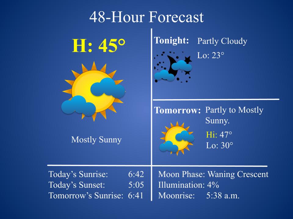
48-Hour Forecast

Extended Forecast

Monday: Partly to mostly sunny & warmer.
Tuesday: Clouds increase. Breezy.
Wednesday – Thursday: Rain likely. Some of the rainfall could be heavy.
Friday: Mostly cloudy and colder. I may introduce light snow for Friday morning in future forecasts. Stay tuned.
Saturday: Mostly sunny.
Radar
https://www.wunderground.com/radar/us/tn/nashville/ohx
MM’s Severe Wx Concerns
Rain, heavy at times, will overspread the plateau Wednesday though Thursday. There are indications that 2-4 inches of rain may fall. As you can see on the forecast map below, the heaviest of the rain may stay just off to our west. Still, we need to be mindful that this system has the potential to produce lots of rainfall for our area, too, though the threat for widespread flooding looks low.

MM’s Winter Wx Concerns
Some guidance is suggesting that there could be some light snow and sleet on the backside of all the rain Thursday night and early Friday morning. Details are very unclear but precip amounts with that continue to look light. Still, stay tune and keep in mind that travel Thursday night and Friday morning may be affected by some light wintry precip. I’ll keep you posted.
On This Day in Wx History
1951- Five inches of snow and ice fall, much of it during the evening, producing a water equivalent of 3.83″. This is the greatest one-day precipitation event for January in Nashville’s history.
Almanac for Yesterday

Save the Hardwoods
If you’re interested in saving the hardwoods from being clear cut on Catoosa please consider signing the petition found below. Thank you! You may also want to check out http://SaveTheHardwoods.com/
https://docs.google.com/forms/d/e/1FAIpQLSflavN4JIaw4nN18fYF3-pw9GMYYo2-D5D5Di6kB0hF7uF1SQ/viewform

MM News
The next MM kids class will be in February. Class is FREE. If you would like to be added to the email list for class notifications just send me an email to meteorologistmark@gmail.com.

An adults class will also be offered next month at TCAT to discuss the severe weather we’ve had this winter. The class is free but any donation goes toward my monthly class for kids at TCAT. Right now I’m raising money to buy tablets for the classes. These tablets will allow students to hold animated weather and space events right in their hands! I have raised $400 thus far, with another $1600 needed.
MeteorologistMarkPro
Weekly newsletter subscription proceeds go toward supporting my education outreach, primarily including the monthly class for kids that I teach at TCAT. Try a free sample at https://meteorologistmarkpro.com/ and go to the “Free Sample” link. Subs are only $5 per month or discounted at $50 a year. Each week’s newsletter primarily focuses on the weather of the plateau. Find out why subscribers are raving on their new weather newsletters!

Keep in mind there is a monthly newsletter for kids for FREE at https://meteorologistmarkpro.com/newsletter-for-kids/! Starting this month, there will be two newsletters for the kids each month, with one being primarily focused on space and the other on weather. Financial support for my time spent on these letters comes from the subscriptions to the weekly newsletter for adults.
Drought Data
The data cutoff for Drought Monitor maps is each Tuesday at 7 a.m. The maps, which are based on analysis of the data, are released each Thursday at 7:30 a.m. This week’s latest map is seen below.

For much more drought info, please follow my link to https://meteorologistmark.com/drought-info/.
Adult Education
If you know anyone who would like to pursue a GED please send them my way! They can reach me by call/text at 931-248-1476 or by email at mark.baldwin@pcsstn.com. I’d love to answer any questions and/or address any concerns. Get the diploma you’ve always wished to have…and it’s all FREE! FYI, my classes are Monday and Wednesday evenings from 4:30 – 7:00 (you can come and go as you need). There’s never boring minute! ha!

You all have a great day and keep lookin’ up!