Weather forecast issued Wednesday, September 6, 2023

Headlines
A chance for rain today & tomorrow.
MM’s Local Weather Concerns:
Widespread severe weather is not expected today, but very isolated strong, possibly severe, storms are possible. The Storm Prediction Center has placed our area in the marginal risk for severe storms for today.
Weather Watchers: Your help may be needed today & tomorrow to record any rainfall from showers & storms that may develop. Also, be sure and report any severe weather that might occur.

MM’s Wx Vlog
Be sure to subscribe for free at https://www.youtube.com/channel/UCz3zLMT7tqpb6eIaE-8YGog
MM’s 5-Day Forecast

Yesterday’s Weather Statistics

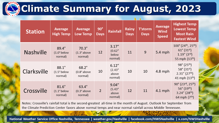
August Statistics for Middle TN
Radar-Estimated Rainfall from Yesterday

On This Day
1925- Temperature at Crossville (Experiement Station) reaches 103, setting an all-time record high.
1929 – Iowa’s earliest snow of record occurred as a few flakes were noted at 9 AM at Alton.
Tropics
There are currently no threats to the U.S., but Tropical Storm Lee is being watched closely. The storm is expected to become a major hurricane by the weekend. At some point next week, this may become a threat to the Northeast.

Emergency Services
I’m so proud to be contracted with Crossville City Fire to provide critical weather support for emergency services!

