Posted on Leave a comment

Afternoon update

We have managed to climb to a high of 71 degrees today! Expect a warm evening with gusty winds. Wind advisories have been issued just to our north in Kentucky. Rain will move in tonight. Friday’s high will occur before lunchtime. A cold front will move through and bring chilly, wet weather for Friday afternoon and night. Showers will continue through Saturday.  Sunday continues to look warm and partly cloudy.

Notice the temperature spread across the country at this hour. There is a huge temperature gradient between the Southeast and the northern Plains.

PLOT_CURRTEMPS_US

You all have a great evening!

Posted on Leave a comment

Hold on to your hats!

Picture5

SUMMARY

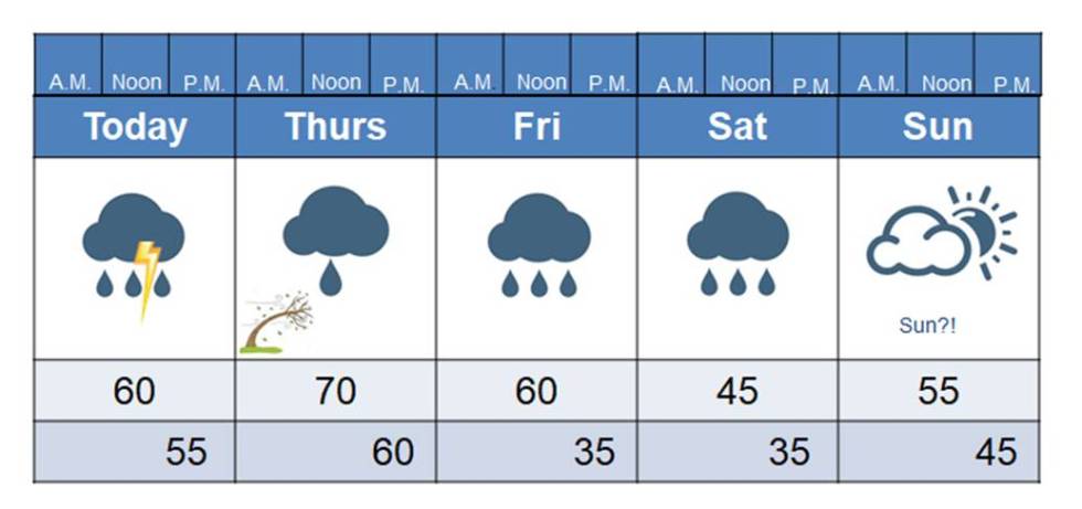
Today will be a very breezy, cloudy day, with isolated showers around. I actually saw  piece of blue sky this morning! It was brief, and at first I thought it was my imagination, but I’m pretty sure it was real (ha). It’s not impossible that we could see a peak or two of sun today, but I wouldn’t work too hard looking for it.  If you’re really wanting some sunshine just hold on until Sunday.

Meanwhile, we have a few more cloudy and wet days to get through. Be aware of those gusty winds today. We are not currently under any wind advisories but the NWS has already said that they change. Winds could gust as high as 30-40 mph by this evening. That’s enough to blow your hat off your head! Seriously, with the ground being so saturated we have to be mindful of shallow rooted trees that may come down (hopefully not on power lines).  Temps will drop tomorrow when the front moves through. That should occur before lunch time. The rest of the day and night will be chilly and wet. It doesn’t look like temps will cool down enough for any wintry precip, though, just a cold rain. That cold rain continues, off-and-on, for Saturday. Warmer air returns for Sunday, as well as some much needed sunshine. Yet another rain maker arrives Monday, with the potential for heavy rainfall and thunderstorms.

Below is the radar at 8:15, showing a broken line of showers moving east. Another line is developing back along the Mississippi River.

RAD_KHTX_N0R

DISCUSSION

It looks like the rainfall for Friday will be on the lighter side.  Most of the precip will fall behind the cold front, where temps will be quite cool. It looks like most of the rain will move out before temps drop into the mid 30s, but some showers will fall at those temperatures. Even if some of the precip does mix with snow, surface temps will stay above freezing and prevent any problems.

I just have showers on Saturday right now, but I seriously contemplated putting the heavier rain symbol on there. It just depends on how strong the disturbance is when it passes through here. All that clears out Sunday morning and we should see some sun peak through the clouds by Sunday afternoon. Right now, Sunday is looking pretty darn good, folks.

Enjoy it.

Yet another rain system will move in Monday. After that point, I’ll have to keep an eye on strong storm chances and heavy rainfall. Right now, the severe weather threat doesn’t look overly impressive but the heavy rain threat does. So far, the models are keeping the greatest flood potential just to our north, as well as back around West TN.  Never the less, I wouldn’t be surprised if we end up getting several more inches of rain next week, by the time all is said and done.

Remember back when I was complaining that we were below normal on precipitation? Yeah, you can forget I ever said that now (ha).

The Climate Prediction Center issues a hazards map and they keep it updated to keep folks aware of the latest threats.

hazards_d3_7_contours

Notice the hazard on us is heavy rainfall for this weekend and again for early next week. I want you to look northward at Montana and the Dakotas. Notice what their hazard is….bitter cold temperatures and heavy snow. You know what bitter cold air likes to do? It likes to travel. It will be interesting to see where it decides to go next. I wouldn’t be a bit surprised if we’re very cold going into March. Notice the much above normal temps for northern Alaska. Interesting.

The dark brown across the southern portion of the country represents severe drought. We pay attention to those soil moisture levels for severe weather season (as well as for crop growing time). Wet soils put more moisture into the air and that moisture is fuel for storms. With dry soil conditions, that moisture is more limited and can limit severe storm potential in the spring.

So, for those of you who are wishing we had snow and colder temps I have a travel destination for you!  Great Falls, Montana is the place you need to be! They are currently under winter storm warnings for some snow today, and this weekend is looking even better for snow! They are, however, under a civil emergency today, due to dangerous cold temps and low visibility from the snow. They’re advising folks not to travel unless it’s an emergency. For those of you who don’t want snow, be thankful this isn’t our forecast!

Picture1

You all have a great day! I have a weather record to share with you tomorrow that’s a doozy! Be sure and check back tomorrow!

Posted on Leave a comment

Keep those umbrellas handy this evening

RAD_KOHX_N0R

The current radar shows another batch of rain is right on our door step, so be sure you have those umbrellas and rain jackets handy this afternoon and evening. We’re still on track for a very warm and windy Thursday, followed by a warm and rainy Friday. Some places across Middle TN are looking to have a record warm night tonight, as temps rise through the night.

The models today show a better chance of seeing the sun on Sunday! If you’ve been missing it, that might be your best day to see it!

You all have a great evening and if you’re headed out for Valentine’s Day, be sure you’re ready to dodge some raindrops.

Posted on Leave a comment

Happy Groundhog Day! Say what?!

Picture7

SUMMARY

Well, for those of you with a Valentine today perhaps your flowers and cards will brighten an otherwise gloomy, rainy day. For those of us without a Valentine, the weather fits the mood, right? (ha).

Look for showers to continue throughout the day and evening, with isolated rumbles of thunder. It will be a very mild day and those temps will only drop off a few degrees tonight, rising before daybreak as another push of warm air surges northward.  That warm air will be riding on some pretty stiff breezes by Thursday afternoon, with gusts to 30 mph possible (maybe stronger). Those breezes are not only bringing up warmer air, but they’re also bringing in more moisture for our next rain maker that will slap us with some pretty good downpours Friday and Saturday. Rain chances have increased now for Saturday with the latest guidance indicating a disturbance that should keep showers around all day. Then, dare I say, the sun could show itself on Sunday. It’s not a great chance, but it’s a chance. Enjoy it because (guess what?) our next rain maker moves in Sunday night and Monday. Expect very mild temperatures next week, with temps flirting with 70.

DISCUSSION

So, what’s up with me wishing you a happy Groundhog Day? Remember when I wrote that article about my Grandpa Baldwin always telling me the real Groundhog Day was February 14th? Remember, it depended on whether or not you use today’s calendar or the calendar that preceded today’s calendar. Well, if today is that day then the groundhog definitely did not see his shadow and spring will arrive six weeks early! So, is the Yankee groundhog from Pennsylvania right, or the southern groundhog of the great state of Tennessee? I guess we shall see!

I’ll tell you one thing, it’s going to feel like spring around over the next week! Tomorrow is going to be downright warm. I’m almost certain we’ll hit 70 degrees and folks all around us, at lower elevations, will hit low to mid 70s. Next week looks like it may be even warmer. But, like I said yesterday, winter will return for at least another visit or two. At least we’re to the point now that even if we do get a cold spell or, God forbid (sigh…) we get a big snow, it wouldn’t last long. The sun’s angle is getting higher everyday and days are getting noticeable longer. It doesn’t take warm air long to return this time of year.

There are early indications that we may be dealing with strong to severe thunderstorms next week. It’s too early to nail down specifics, but we’re going to be either at or slightly above 70 degrees and more systems will be moving through. It doesn’t take a genius (or even a meteorologist! HA) to know that kind of weather can spell trouble in February. I’ll keep an eye on it.

Speaking of severe weather, of the 25 total tornadoes ever recorded in Cumberland County, three occurred in February. One was the most recent Leap Day tornado (2-29-12) that hit the north end of the county in Rinnie.  That remains our second deadliest twister on record, having claimed two lives. Before that tornado was the February 21st tornado of 1993 that paralleled the interstate through Crab Orchard. That tornado was part of an outbreak of Tennessee tornadoes that came just weeks before the blizzard of ’93 hit. The other was a tornado in 1899 that would have traveled very near, if not right through, the current location of Walmart. The only significant damage it did was blow the roof off Munroe Hyder’s barn, with the stock inside uninjured (according to the storm report filed). Numerous trees were destroyed, however, as well as a vast amount of fencing.  That would be a much different story today!

We don’t have any severe weather or wintry weather to worry about anytime soon. Mild and wet weather will rule the forecast for the next week or so. I’m still betting we’ll see a decent shot of cold air in here the beginning of March, though,  so I’ll be keeping a close eye on that.  If you recall, we had not received any snowfall at this point in the winter of 1993, the year of the March blizzard. It had been a very mild winter and it was basically too warm to snow until the second half of February. The cold front that brought the tornadoes on the 21st really started a pattern change. I’ll have so much more on this as we approach the 25th anniversary of the blizzard of ’93.

You all have a great day and try to stay dry on this Groundhog day/Valentine’s Day!  🙂