At a Glance
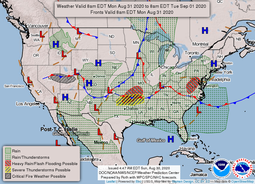
48-Hour Weather

Threats
The threats facing us this week include a locally damaging wind gust with any storm that develops, as well as cloud-to-ground lightning and heavy rainfall that could lead to localized flash flooding.
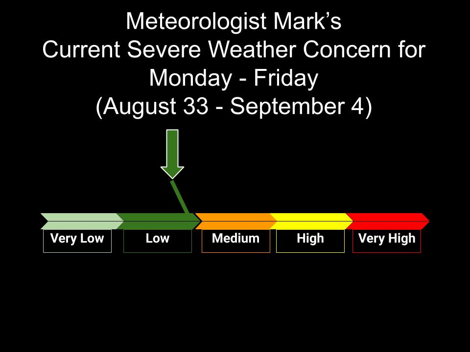
Baldwin’s Severe Weather Concern
Baldwin’s 7-Day forecast

Daily Forecast
Today: Showers and storms likely, especially in the afternoon/evening. Otherwise mostly cloudy.
Tuesday: Scattered showers and storms, especially in the afternoon/evening hours.
Wednesday – Friday: A chance for showers and storms, mainly in the afternoon/evening. Otherwise, partly cloudy, warm and humid. A cold front on Friday should bring us better weather for the weekend.
Saturday – Sunday: Partly cloudy and pleasant. Just a slight chance for an afternoon/evening shower or storm on Sunday.
Baldwin’s Hay Day Forecast
This week continues to look very unsettled, with better weather expected behind a cold front that will pass through on Friday. Next week may hold our first shot of fall-like temperatures.

Almanac

Yesterday’s National High and Low Temperature
High: 113 at Death Valley, California
Low: 28 at Sunriver, Oregon & Peter Sinks, Utah & Stanley, Idaho
Tropics
The two areas of greatest concern are no threat to the US. The one off the East Coast is moving out to sea, while the one in the Caribbean is moving into Central America. The other two areas of concern out in the Atlantic will need to be watched closely, as they track across the ocean this week.

Today’s Wx Hazards Across the Nation
Heavy rainfall threatens parts of western North Carolina and western Virginia. Another area of both heavy rainfall and severe weather threatens parts of the southern plains and Midsouth. A wildfire danger continues for parts of Nevada and Utah, while wintry precip threatens parts of Idaho, southern Montana, and western Wyoming.

Tomorrow’s Wx Hazards Across the Nation
The main threat tomorrow is that extensive area of heavy rainfall across the southern plains. That stretches into parts of the Lower Mississippi River Valley.

Wednesday’s Wx Hazards Across the Nation
And that heavy rainfall threat remains on Wednesday, even stretching eastward a bit more. A wildfire danger develops across parts of eastern Montana and the western portions of the Dakotas.

On This Day
On this day in 1954 Hurricane Carol swept across eastern New England, killing sixty persons and causing 450 million dollars damage. It was the first of three hurricanes to affect New England that year.
Long Range Outlook
Look at all that cooler air coming down for this period of time! This is for the 5th through the 9th of September. Normal highs this time of year are in the lower 80s, with lows in the lower 60s, so anything below that is below normal. I’m anxious to see if future extended outlooks bring that cooler air on south. Rainfall looks to be about normal, to slightly above normal.
Temperature

Precipitation

Weather Shot
Severe-warned storm north of Dalhart, Texas on Saturday. What an absolutely incredible shot! It looks like a spaceship. Photo by Jake Thompson (@ChaserJake94).

NASA Nerdology
Speeding race car drivers are in the hot seat in more ways than one. Temperatures inside a stock car’s cockpit can soar to an estimated sweltering 160 degrees Fahrenheit. That extreme heat comes through the engine firewall, transmission tunnel, and floor.
Based on materials used to protect the space shuttle from the temperatures experienced as the crafts slammed back into Earth’s atmosphere (and faced temperatures up to 3,000 degrees Fahrenheit), a company created blanket insulation kits to shield race car drivers from excessive heat exposure.
Another byproduct of racing is combustion fumes that can cause headaches, nausea, and dizziness. Racing engineers adapted a NASA space technology to create a filter that removes 99% of all airborne particles. The filter provides drivers with fresh, clean air.

You all have a great day!