Welcome! Please be sure and follow this site by finding that “Follow” button in the lower right corner of your screen.
Thank you!
Video At a Glance
48-Hour WX

Seven-Day Forecast

Daily Forecast
Today: Becoming mostly sunny. Highs in the low to mid 60s. Overnight lows in the mid 40s.
Tuesday – Thursday: Mostly sunny and pleasant. Highs in the low to mid 70s and overnight lows near 50°.
NOTE: The forecast beyond this point is heavily dependent upon the exact track of “Delta”. Stay tuned.
Friday: Becoming mostly cloudy, with showers developing by afternoon/evening. Highs around 70°, overnight lows in the mid to upper 50s. Becoming breezy.
Saturday: Rain and thunderstorms likely. Highs around 70°, overnight lows in the 50s. Winds could be quite gusty.
Sunday: Rain tapers off to showers. Highs around 70°, with overnight lows dropping into the lower 50s.
Threats
No hazardous weather is expected through Thursday.
For Friday and the weekend, the exact track of “Delta” will determine how much of an impact we get from that system. If current guidance verifies, we could see some heavy rainfall and gusty winds. It is too soon to evaluate any sort of severe t-storm threat, so stay tuned.
Meteorologist Mark’s Severe Wx Concern
A dry and stable airmass will keep our area storm-free through Thursday.

The severe weather threat on Saturday depends on the exact track of Delta. If the system stays south of the plateau, the severe weather threat will be very low to zero. If the system passes over or just to the west of the plateau, that threat will be much higher. I’ll keep an eye on it.

Hay Wx Forecast
The better part of this week is looking GREAT for Fall hay weather harvesting! However, it now looks likely that “Delta” will move toward our neck of the woods by Friday, bringing rain and thunderstorms to our area. I would plan to wrap up any hay work by Thursday evening, just to be safe.

On This Day in Wx History
On this day in 1995, the remnants of Hurricane Opal moved across Middle Tennessee. Southern Cumberland County received as much as 7.80″ of rain. Numerous trees were downed across the plateau, as a result of very gusty winds and saturated soils.
Almanac

Yesterday’s National Temperature Extremes
High: 108° at both Brawley and Winterhaven, California
Low: 14° at Peter Sinks, Utah
Tropical Outlook
All eyes are on Tropical Storm Delta and what that storm ultimately does. The storm is expected to strengthen into a hurricane, as it moves through the central Gulf of Mexico. Landfall is expected near the Louisiana/Mississippi coastline sometime Friday morning (though that could change). The exact track beyond that will determine what impacts we experience. Stay tuned. At this time, Delta is expected to be a cat 2 hurricane at landfall, with winds near 100 mph.

We still have Tropical Storm Gamma in the southern Gulf, and it has a very messy path forecast over the next week. Interaction with Delta will likely have an impact on this system. It still does not look like Gamma will impact the US, but the forecast is very uncertain, due to the difficulty in forecasting the interaction with Delta, as well as with other complex atmospheric circumstances around Gamma this week.

Today’s National Wx Hazards
A wildfire danger persists across parts of the central plains (gray-shaded region), while Tropical Storms Gamma and Delta can be seen in the lower portion of the map.

Tomorrow’s National Wx Hazards
The most interesting features on this map are Tropical Storms Gamma and Delta. All eyes will be on Delta, as that storm makes its way northward this week.

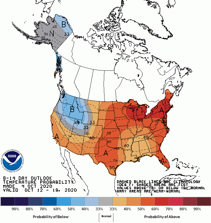
8 – 14 Day Outlook
The extended outlook shows very warm temps in the Northeast, while very cool temps settle into the Pacific Northwest. This outlook does not bode well for the drought in the Northeast. Our region is looking warm and wet, a likely result from tropical influences.
Temperature
Precipitation

Weather Shots
Today’s weather shot is from the Upper Peninsula of Michigan by Barry Butler (@barrybutler). Barry shot this over the weekend and noted that, “Autumn is alive.”

NASA Nerdology
This was a beautiful shot of the Antares rocket on its launch pad just before being successfully launched Friday night from Wallops Island, Virginia. The cargo consists of 8,000 pounds of supplies and science experiments. The cargo arrives at the International Space Station this morning.
Seriously, how beautiful is this pic?!
