Headlines
A nice couple of days of warmer sunshine!
A very wet weekend
Watching for flooding concerns this weekend
Meteorologist Mark’s Wx Vlog
48-Hour WX

Five-Day Forecast
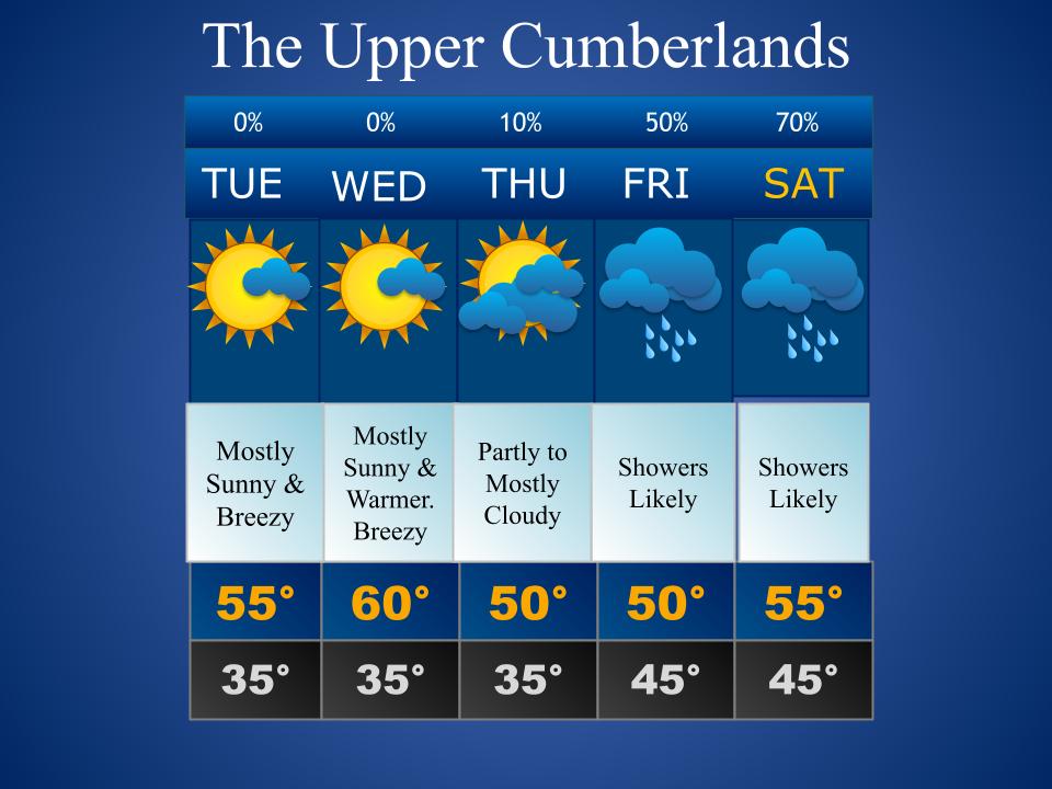
Daily Forecast Summary
Today & Tomorrow: Mostly sunny and warmer. Breezy.
Thursday: Partly to mostly cloudy skies. A slight chance for cold rain showers overnight.
Friday: Mostly cloudy with scattered showers.
Weekend: Rain likely. Some of the rainfall could be heavy.
48-Hour Precip Forecast

Meteorologist Mark’s 5-Day Wx Concerns

Meteorologist Mark’s Wx Discussion
Honestly, I struggled a bit with today’s 5-day forecast. That struggle is centered around Thursday night.
If you’ll recall, I’ve mentioned before that some guidance has suggested we could see some snow in that timeframe but that I just wasn’t buying it. I’m still not….to a great extent. The problem for me is that SO many things would have to come together just right. The moisture would have to make it this far north (30% chance of that). The moisture would have to come at the coldest part of the night (20% chance of that). Surface temps would have to drop to freezing for accumulation (10% chance for that). Our snows are iffy enough around here but that “iffyness” usually involves us being certain of getting precip, we’re just often uncertain about temps cooperating.
I’ll keep an eye on things and see how guidance leads me today. I wouldn’t hold my breath for any big changes, though. Just an interesting, FYI.
The weekend is looking wet. I would strongly advise against making outdoor plans. I would advise you to change those plans if they’re already made. We’re looking at 2-3 inches of rain but there is the potential for an inch or two more than that, it just depends on how it all lines up. It will be all rain and a warmer rain at that. The severe threat should stay well to our south and where it should be in February.
On This Day in Wx History
1936 – A severe blizzard in the Sierra Nevada Range closed Donner Pass. It stranded 750 motorists and claimed seven lives. The infamous Donner party incident had happened 90 years prior, but I’m sure that never crossed these motorists minds……………
Almanac

24 Days until Spring!

Yesterday’s National Temperature Extremes
High: 87° at Punta Gorda & Sebring, Florida & Santee, California
Low: -15° at Pittsburg, New Hampshire
Today’s National Wx Hazards
Wintry weather can be found along the northern tier of the county, with the most impactful weather being accumulating snowfall along the US/Canada border, as well as across the Rockies.

Tomorrow’s National Wx Hazards
A rain/snow mix falls on much of the northeastern US, with little impact. Accumulating snowfall will cause greater impacts across parts of the Great Lakes and Upper Midwest, as well as across much of the Rockies and Front Range.

Weather Shots
This is a timelapse of a giant slab of ice on Lake Michigan breaking and drifting away from Chicago this past weekend. From what I understand, this happens often on the Great Lakes, sometimes even trapping ice fishermen on the floating slabs! Video compliments of @Tom Skilling. How wild is that?
NASA Nerdology
The Juno spacecraft is in its fifth year of circling Jupiter and it’s still sending back absolutely stunning images! This image highlights the many jet streams, much like Earth’s, that circle the planet. Images like this have helped scientists confirm that the these jetstreams penetrate as much as 1,800 miles into the gaseous planet! That’s incredible! Research on Jupiter, like all other space research projects, helps us better understand our own planet and, in this example, our very own jetstreams!
