The National Hurricane Center has just determined that the area of low pressure out in the Atlantic is now a tropical depression. This was the red hatched area I talked about in this morning’s blog. The path is a bit concerning, as you can see below. If you or someone you know has Gulf Coast beach plans next week, they need to be aware of this. Keep in mind that this path will likely change in future forecasts, but this is certainly raises many eyebrows tonight. It is far too early to tell what this means for the plateau, but with this forecast track, it’s something I’ll have to watch closely.
Today: Partly to mostly sunny, with scattered mainly afternoon and evening showers and thunderstorms.
Thursday: Scattered showers and thunderstorms.
Friday: Partly to mostly cloudy, with scattered showers and thunderstorms.
Saturday & Sunday: Mostly sunny. Low humidity. Very nice!
Monday & Tuesday: A bit more humid, but continued mostly sunny.
Hay Weather Forecast
Forecast Discussion
The front that will push through here Thursday will set the stage for one of the nicest Fourth of July weekends I think I’ve ever seen us have! Low humidity and highs in the 70s will feel quite nice!
Meteorologist Mark’s Wx Concerns
The Storm Prediction Center has NOT highlighted our area in any threat, but keep in mind that storms this time of year can become quite strong. Gusty winds, cloud-to-ground lightning, and very heavy rainfall are possible with any storm that develops today and tomorrow. Be safe.
Almanac for Yesterday
Tropics
The tropics are looking very concerning. The red-dashed area is of greatest concern. This is still a long ways out, but it is certainly something many of us will be tracking!
Sun & The Moon
Planting by the Moon
30th – 30th Cut hay or do plowing on this barren day.
July
1st – 2nd A barren period.
3rd – 4th Good days for transplanting. Root crops that can be planted now will yield well.
5th – 7th Poor days for planting, seeds tend to rot in ground.
8th – 9th Plant seedbeds and flower gardens. First day is a good day for transplanting. First day is also most fruitful day for planting root crops. Second day is most favorable for corn, cotton, okra, beans, peppers, eggplant, and other aboveground crops
10th – 14th A most barren period. Kill plant pests and do general farm work.
15th – 16th Sow grains and forage crops. Plant flowers. Favorable for planting peas, beans, tomatoes, and other fall crops bearing aboveground.
On This Day in Wx History
1952- Temperature at Nashville reaches 106, marking the 8th consecutive day of 100+ degree readings, a record.
Yesterday’s National Temperature Extremes
High: 121° at Death Valley, California
Low: 28° at Albany, Wyoming
Wednesday Weather Wisdom
The atmosphere keeps our planet warm through a process called the Greenhouse Effect. Heat from the sun penetrates our atmosphere as shortwave radiation. That short-wave radiation is what leaves the sun. That radiation strikes the Earths’ surface and then “bounces” off the surface as longwave radiation. Some of that longwave radiation gets trapped by the atmosphere. That radiation keeps us warmer at night than we would otherwise be. Planets with no atmosphere have dramatic heating during the day, followed by dramatic cooling at night. Our atmosphere acts as a blanket, of sorts. Shortwave radiation can move through the atmosphere more easily than longwave.
Today’s Tennessee Weather
A hot and humid June Wednesday is in store for Tennessee. That heat and humidity will lead to scattered showers and thunderstorms, especially in the afternoon and evening. A few of the storms could be strong. Afternoon highs will climb into the mid to upper 80s. Be safe if you’re outside in the hottest part of the day.
Tonight’s Tennessee Weather
A warm and muggy night will lead to a few showers and thunderstorms across the state. Otherwise, look for partly to mostly cloudy skies, with low temperatures around 70 degrees.
Tomorrow’s Tennessee Weather
A cold front charges in from the west! That will lead to a near 100% chance for showers and thunderstorms statewide. With clouds and rain, afternoon highs will generally only be in the low to mid 80s across the area. A few of the storms could be strong, but widespread severe weather is not expected with this frontal passage.
Drought Monitor
The drought monitor is updated each Thursday.
Weather SnapShots
A weather camera in southern Middle TN had a guest ready for their Hollywood debut! (haha) Why does this remind me of Bigfoot?
NASA Nerdology
During this week in 1965, Joe Engle piloted the X-15-2 research aircraft over 50 miles above the Earth’s surface, which qualified him for astronaut wings under the US Air Force definition. Joe is the only person who had flown in space before his selection as a NASA astronaut in 1966.
You all have a great day and keep lookin’ up!
Note: To offer support to Meteorologist Mark and his educational outreach programs, please consider giving via https://www.paypal.com/paypalme/meteorologistmark. If you can’t give, no worries! Just keep following and tell your friends!
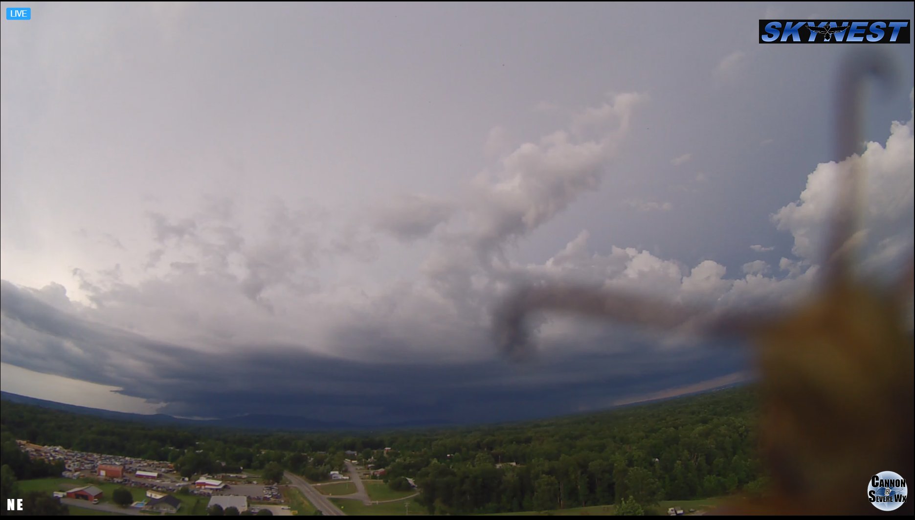
Like yesterday evening, we have more storms moving in for this evening. Keep in mind that storms are moving westward. Normally, storms move in from Nashville. Today, they’re moving in from Knoxville. In fact, they’re moving toward the northwest, to be exact. We tend to get storms with some kick when they come from an eastward direction.
The radar below shows a strong storm moving into the southeast part of Cumberland County. It’s moving toward Crossville and should be there by about 5:30, if it holds together. Fairfield could be impacted by 5:00.
Just be mindful of gusty winds, cloud-to-ground lightning, and torrential rainfall with any storm. These are moving in an odd direction because they’re being steered by the remnants of Tropical Storm Danny that made landfall in South Carolina about 24 hours ago.
The all-time record high for Crossville was recorded on this day in 2012. That temp was 102 degrees! Learn more in the “On This Day in Wx History” section below.
Weather Headlines
Getting wetter as we go through the week
The holiday weekend is trending drier!
Pleasant temps coming for the weekend
Watching the tropics!
Meteorologist Mark’s Wx Vlog
Unavailable today
Seven-Day Forecast
Daily Forecast
Tuesday & Wednesday: Partly cloudy, with scattered mainly afternoon/evening showers and thunderstorms.
Thursday & Friday: Mostly cloudy, with scattered showers and thunderstorms likely.
Saturday & Sunday: Partly to mostly sunny, with a slight chance for a shower or thunderstorm.
Monday: Mostly sunny.
Hay Weather Forecast
Meteorologist Mark’s Wx Concerns
Almanac for Yesterday
Tropics
Tropical Storm Danny quickly strengthened into a storm just before making landfall on the coast of South Carolina yesterday evening. The remnants of that system are now moving through Georgia and Alabama.
Now, we have two areas to watch in the Atlantic! This looks more like a map from August than from June. Both systems are days and days away from being a concern for any land, but they’re both worth tracking.
Sun & The Moon
Planting by the Moon
29th Set strawberry plants. Excellent for any vine crops such as beans, peas, and cucumbers. Good days for transplanting. Favorable time for planting late root crops.
30th – 30th Cut hay or do plowing on this barren day.
July
1st – 2nd A barren period.
3rd – 4th Good days for transplanting. Root crops that can be planted now will yield well.
5th – 7th Poor days for planting, seeds tend to rot in ground.
8th – 9th Plant seedbeds and flower gardens. First day is a good day for transplanting. First day is also most fruitful day for planting root crops. Second day is most favorable for corn, cotton, okra, beans, peppers, eggplant, and other aboveground crops
10th – 14th A most barren period. Kill plant pests and do general farm work.
15th – 16th Sow grains and forage crops. Plant flowers. Favorable for planting peas, beans, tomatoes, and other fall crops bearing aboveground.
On This Day in Wx History
2012- An abnormally hot, dry air mass settles over Middle Tennessee. Nashville sets its all-time record high temperature, reaching 109 degrees. Crossville also sets a new all-time record high at 102. It’s only the 2nd time Crossville has ever reached triple digits. Other all-time record highs are set at Neapolis (110), Woodbury (110), Columbia (109), Kingston Springs (109), Cheatham Dam (108), Franklin (108), Lafayette (108), Shelbyville (108), Sparta (108), Mt. Pleasant (107), Lawrenceburg (106), McMinnville (106), Old Hickory Dam (106), Portland (106), Pulaski (106), Springfield (106), Bethpage (105), Cookeville (105), Gainesboro (105), Jamestown (103), and Monterey (103).
Yesterday’s National Temperature Extremes
High: 126° at Death Valley, California
Low: 30° at Berthoud Pass, Colorado
Twister Tuesday
There are often bizarre stories from tornadoes, such as straw being blown into a tree. The way this occurs may come from how the tree behaves in the wind. As the tree bends, areas of the trunk are weakened and the straw may find its way into one of the weaker spots. Then, when the wind subsides the tree stands back upright, with the straw firmly in place.
The image below shows a tree that was bent over in a tornado but was unable to stand upright gain. It’s in this position during the storm that objects may become impaled into the tree.
Today’s Tennessee Weather
It’s another muggy day across Tennessee, with a chance for scattered showers and thunderstorms, especially in the afternoon and evening hours. Afternoon highs will be near 90 degrees, but the higher humidity will make it feel much warmer. Stay cool and stay safe around any thunderstorm that develops!
Tonight’s Tennessee Weather
There will be a continued chance for a shower or storm on into the evening hours. Much, if not all, of that activity should subside by midnight. Otherwise, look for partly to mostly cloudy skies and lows around 70 degrees.
Tomorrow’s Tennessee Weather
Skies will be partly to mostly cloudy across the state, with scattered showers and thunderstorms. Once again, those rain chances are highest in the afternoon and evening hours. Afternoon highs will generally be in the upper 80s, with high humidity levels.
Drought Monitor
The drought monitor is updated each Thursday.
Weather SnapShots
I took this sunset picture at the Career Center yesterday evening. What a beautiful sunset it was!
NASA Nerdology
in 2011, astronomers using NASA’s Hubble telescope discovered a fourth moon orbiting Pluto, Kerberos (labelled below as “P4”). All of Pluto’s moons are named for mythological figures associated with the underworld. Kerberos is named for the three-headed dog of Greek mythology.
You all have a great day and keep lookin’ up!
Note: To offer support to Meteorologist Mark and his educational outreach programs, please consider giving via https://www.paypal.com/paypalme/meteorologistmark. If you can’t give, no worries! Just keep following and tell your friends!