Weather Headlines
Dodging Afternoon Storms
Heat & Humidity Continue
Tracking a Tropical System Toward Tennessee
MM News
You can buy Meteorologist Mark shirts this week at the Cumberland County Fair! We will be selling Meteorologist Mark shirts and Bigfoot merchandise at the Bigfoot booth this week. You can stock up on Bigfoot Festival merchandise, or get a Meteorologist Mark shirt! Or, just stop by and say hello! We’re located near the stadium, behind the Gideon’s tent.
I won’t be there tonight, but I’ll be there Friday evening. See you there!
Radar & Wx Alerts Link
Radar can be found here:
https://www.wunderground.com/maps/radar/current/bwg
Weather alerts can be found here:
https://www.wunderground.com/wundermap
Meteorologist Mark’s Wx Vlog
Seven-Day Forecast

Daily Forecast
Thursday: Partly to mostly cloudy, with scattered showers and thunderstorms.
Friday – Saturday : Partly to mostly sunny, with a slight chance for an afternoon shower or thunderstorm.
Sunday: Partly to mosty sunny, with a chance for afternoon showers and thunderstorms.
Monday: Partly to mostly cloudy, with scattered showers and thunderstorms.
Tuesday – Wednesday: Rain likely, along with gusty winds.
MM’s Wx Concerns
Be safe in the heat and be safe around any storm that develops.


Hay Weather Forecast
A tropical system begins arriving Monday. Get your hay work wrapped up before then!

Meteorologist Mark Pro
The latest WeatherLetter is out again this week! Check that out for free for 7 days at https://meteorologistmarkpro.com/! This week’s topics include the flooding west of Nashville on Saturday, glass on the Moon, and “Fred’s” flooding in the Appalachians. Check those stories out and more today!
Today’s Stats

Almanac for Yesterday

On This Day in Wx History
2007- The temperature hits 94 degrees at Nashville, the 32nd consecutive day with 90+ degree readings, a record. The average high temperature during this remarkable stretch is 98.2 degrees.
Yesterday’s National Temperature Extremes
High: 116° at Death Valley, California
Low: 22° at Choteau, Montana
Today’s Tennessee Weather
It’s a hot and humid Thursday. Be safe out in the heat. A few afternoon showers and thunderstorms will bubble up in the heat of the afternoon. That rain chance is about 30%, with slightly higher chances across the higher elevations. Afternoon highs will be in the low to mid 90s statewide.

Tonight’s Tennessee Weather
A few storms may linger into the evening in the central and eastern portions of the state. Otherwise, look for clear to partly cloudy skies overnight, with lows around 70 degrees.
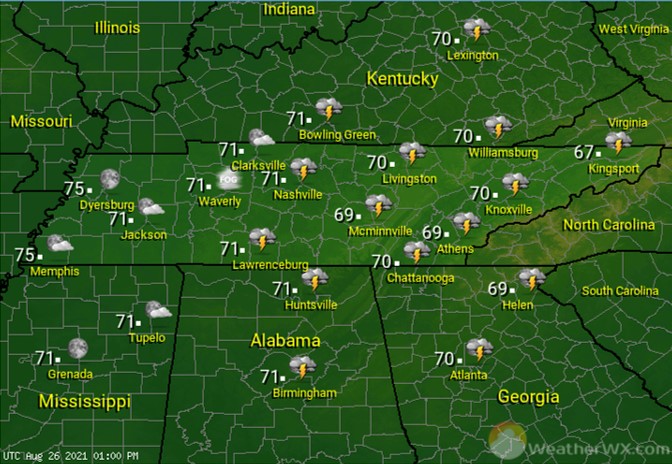
Tomorrow’s Tennessee Weather
The workweek will end as much of the week has been; hot and humid, with an isolated shower or storm possible in the afternoon and evening. Afternoon highs should climb into the lower 90s statewide.

Tropics
A hurricane reconnaissance aircraft will be investigating that system in the Caribbean this afternoon. That system is expected to become a tropical depression or tropical storm within the next 24 hours. The storm is then expected to enter the southern Gulf of Mexico Friday night. From there, the system should track toward the Gulf Coast, likely toward the Louisiana area. This has the potential to be a significant hurricane and everyone along the Gulf Coast, from Texas to Florida, is strongly encouraged to monitor this system in the coming days.
At this time, it looks like that storm will move toward Tennessee by Tuesday. That could bring us heavy rainfall, gusty winds, and even severe weather, depending on the exact track of the storm.

I should note that the orange-shaded area is not to be dismissed. We have plenty of time to track that system and hopefully it will curve out to sea. Incidentally, the other red-shaded area out in the Atlantic should move away from the US.
Sun & Moon

Past 24-Hour Earthquake Activity
The size of the dot indicates the strength of the quake. Red dots represent the most recent quakes.

Tracking the Fire and Smoke
