
Tracking another strong cold front
MM’s Wx Vlog
Seven-Day Forecast
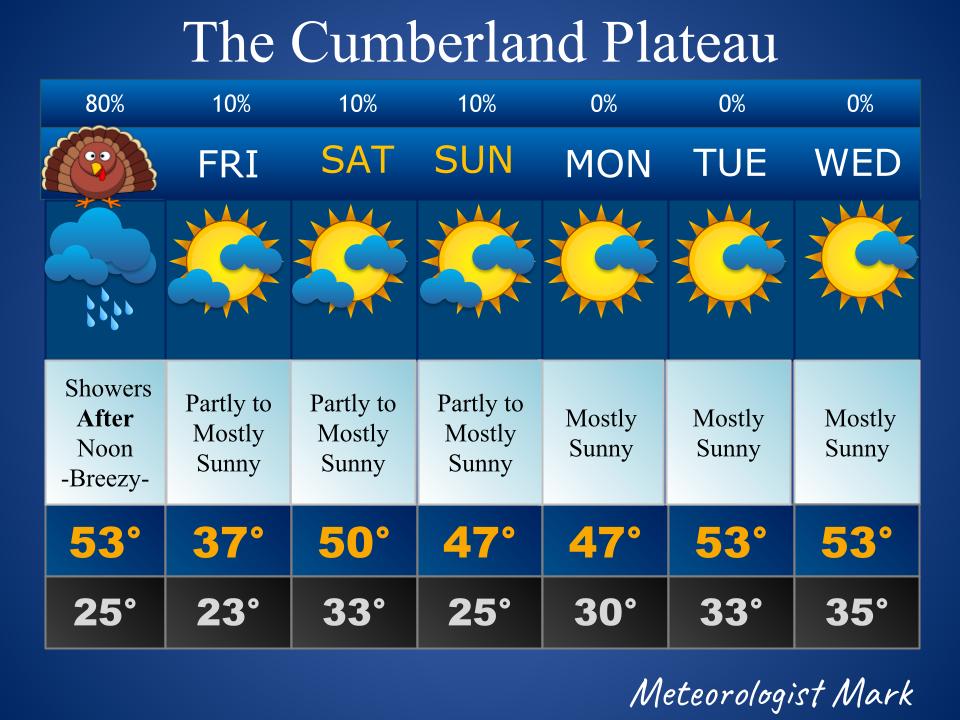
Thanksgiving: Showers likely after noon. Mild. Turning sharply colder overnight, with perhaps a couple snow flurries while we sleep off our turkey feast.
Friday: Partly to mostly sunny. Cold.
Saturday: Partly to mostly sunny. Mild.
Sunday – Monday: Partly to mostly sunny. Cool.
Tuesday – Wednesday: Partly to mostly sunny. Warmer.
Radar
https://www.wunderground.com/radar/us/tn/nashville/ohx
MM’s Wx Concerns
Very cold air will move in once again tonight. Make sure the outside fur babies are sheltered and warm.

Today’s Stats

Almanac for Yesterday

Today’s National Wx Map (New!)
A strong cold is moving through the Mississippi River Valley today. Ahead of that front there are rain showers, and behind that front is much colder air. We’ll get the showers by this afternoon and evening. The cold air will arrive overnight.

Rainfall Amounts Expected Today (New!)
Rainfall amounts for the plateau are expected to stay around one quarter of an inch (0.25), to possibly as much as one half inch (0.5) with this system.

National High Temps for Today (New!)
Rain showers will keep parts of Tennessee and Kentucky cooler today.

National Low Temps for Tonight (New!)
The passing cold front will turn many of us cooler tonight!

24-Hour Temperature Change (New!)

On This Day in Wx History
1950 – A great storm hit the Northern and Central Appalachians with snow and high winds. Winds reached hurricane force along eastern slopes of the Appalachians, with gusts to 100 mph at Hartford, Connecticut, 110 mph at Concord New Hampshire, and 160 mph at Mount Washington, New Hampshire. Heavy rain also hit the eastern slopes, with eight inches reported at Slide Mountain, New York. The western slopes were buried under heavy snow. The storm produced record snowfall totals of 27.7 inches at Pittsburgh, Pennsylvania, and 36.3 inches at Steubenville, Ohio. The snow, and record cold temperatures, resulted in 160 deaths.
MM News
December’s MM Kids class will feature a lesson on weather folklore! Stay tuned for a date and registration info!
Drought Monitor
The data cutoff for Drought Monitor maps is each Tuesday at 7 a.m. The maps, which are based on analysis of the data, are released each Thursday at 7:30 a.m.
This is the latest map, released today!
Southeast
Half an inch to an inch of rain fell across northern parts of the Southeast region this week, and half an inch to locally more than 2 inches fell over southern and eastern parts of the Florida coast, but areas in between had less. Little to no precipitation fell over portions of southeast Alabama to much of Georgia. With the exception of parts of Florida, all of the Southeast had a drier-than-normal week. Subnormal precipitation over the last week to 3 months further dried soils. Moderate drought expanded in the Carolinas and Virginia with abnormal dryness growing in these states, Alabama, and Georgia.

Today is the first day in weeks that the rainfall for the plateau is in a deficit. It’s not much, just over a tenth of an inch, but it’s the driest we have been in many weeks.


Meteorologist Mark Pro
Each week’s newsletter has two short stories/lessons in it, along with some other tidbits of interesting information. In this week’s newsletter you’ll find a story about getting snow at 50 degrees! It’s even happened here! The other story is about something called the “plane of the ecliptic” in astronomy and what that means for us here on the plateau. These stories and more are available for subscribers at https://meteorologistmarkpro.com/.
Subscriptions to the weekly newsletter go to support MM’s education outreach, including the FREE monthly kids newsletter available at https://meteorologistmarkpro.com/! Subs are just $6 a month if you pay monthly and only $5 a month if you pay annually! That’s quite the deal for a local weekly newsletter that’s always very interesting! Thank you!


HAPPY THANKSGIVEN TO YOU AN YOUR FAMILY.THANKS FOR YOUR WEATHER FORCASTS YOU KEEP US UPDATED ON WHAT THE WEATHER DOING.YOU UPDATE US THE TIME THE STORMS OR COMING IT MEANS A LOT TO US SO THAT LETS US KNOW WHAT TO DO.STAY SAFE AN KEEP THEM FORCASTS COMING.