Weather forecast issued Saturday, September 2, 2023
Headlines
An extended period of warm & dry weather has begun.
Watchiing a new tropical disturbance coming across the Atlantic.
MM’s Local Weather Concerns:
Weather Watchers: Enjoy the break! Severe storms are not expected for the next five+ days.
MM’s Wx Vlog
Be sure to subscribe for free at https://www.youtube.com/channel/UCz3zLMT7tqpb6eIaE-8YGog
MM’s 5-Day Forecast

Yesterday’s Weather Statistics

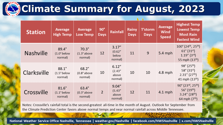
August Statistics for Middle TN
Radar-Estimated Rainfall from Yesterday

On This Day
1954- An arid air mass produces some rarely observed temperature ranges across the mid state. At Crossville, the morning low of 44 degrees sets a record for this date. The temperature subsequently rises to 90 during the afternoon — just 2 degrees off the record high. At Nashville, a 40-degree difference between high (95) and low (55) is observed.
1935 – Perhaps the most intense hurricane ever to hit the U.S. struck the Florida Keys with 200 mph winds. The hurricane produced a fifteen foot tide and waves thirty feet high. Four hundred persons perished in the storm on that Labor Day. The barometric pressure at Matecumbe Bay, Florida, hits a record low for the U.S. of 26.35 inches.
Tropics
The tropics remain active but the only potential area of concern for the U.S. is the disturbance headed into the red-shaded region. That vigourous disturbance has moved off the coast of Africa and is one to watch over the next 7-10 days.

Emergency Services
I’m so proud to be contracted with Crossville City Fire to provide critical weather support for emergency services!

