Weather forecast issued Sunday, September 3, 2023

Headlines
An extended period of warm & dry weather has begun.
Watching a new tropical disturbance coming across the Atlantic.
MM’s Local Weather Concerns:
Weather Watchers: Enjoy the break! Severe storms are not expected for the next five+ days.
MM’s Wx Vlog
Be sure to subscribe for free at https://www.youtube.com/channel/UCz3zLMT7tqpb6eIaE-8YGog
MM’s 5-Day Forecast

Yesterday’s Weather Statistics

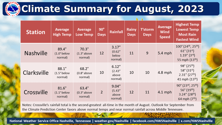
August Statistics for Middle TN
Radar-Estimated Rainfall from Yesterday

On This Day
1954- Arid weather continues, as Nashville hits 101 degrees, following a morning low of 60. At Crossville, the high temperature hits 93, despite a morning low of 50 degrees.
1961 – Denver, Colorado, received 4.2 inches of snow, their earliest snow of record.
Tropics
The tropics remain very active, with two tropical storms and two more likely on the way. Thankfully, Gert and Katia will stay out at sea. The yellow-shaded region near Africa is a brand new concern this morning, but it will also likely stay out at sea. The red-shaded region

The next named storm, which will likely develop in the red-shaded area above, will be “Lee.”

Emergency Services
I’m so proud to be contracted with Crossville City Fire to provide critical weather support for emergency services!

