Be sure to “Follow” the blog and get updates emailed straight to your inbox! Just find that “Follow” button in the lower right corner of your screen. Thank you!
At a Glance
48-Hour Weather

Threats
Hazardous weather is not expected over the next 7-10 days.
Baldwin’s Severe Weather Concern
After some showers today, a very stable atmosphere will move in, preventing any severe weather for many days.

Baldwin’s 7-Day forecast

Daily Forecast
Today: Mostly cloudy, with a chance for a widely scattered shower/sprinkle. Most of us should stay dry.
Friday: Decreasing clouds. Becoming nice.
Saturday: Partly cloudy. Pleasant.
Sunday – Wednesday: Mostly sunny, fall-like, and pleasant. Enjoy!
Today’s Choice of Outdoor Activity (New section!)
YARD WORK!
With cool and cloudy conditions expected today, it’s a good time to work in the yard/garden. Just be ready to dodge a light shower or sprinkle….perhaps.
Baldwin’s Hay Day Forecast
After we get past a slight chance for showers/sprinkles today, we are all set for a really nice stretch of good weather! This nice weather could last through all of next week, too!

Almanac

Yesterday’s National High and Low Temperature
High: 114° at both Ocotillo Wells & Mecca, California
Low: 21° at Walden, Colorado
Tropics
The area of red-shading in the southwestern Gulf of Mexico is our most immediate concern to the US. It had looked like that would either dissipate or move into Mexico. Now, neither one of those options look likely. In fact, guidance is trending toward that system becoming a tropical storm and impacting the northern Gulf Coast at some point. Hurricane Hunters are investigating that system today and I’ll let you know what they find out.
Farther east, Hurricane Teddy has strengthened again this morning into a cat 2. It looks like he will brush Bermuda in the coming days and then try to possibly swing westward toward Maine at some point. That’s an odd track that will likely not verify, but we’ll watch it.
Vicky continues to weaken, so that’s good news. The orange-shaded region in the southern Atlantic could become a named storm over the next week. If so, that would be Alpha, because if Wilfred develops in the Gulf we’ll be out of names. We have never had to use the Greek alphabet this early. In fact, we’ve only used it in one other season (2005) and we didn’t need the Greek alphabet then until October 22nd of that year!

Today’s Wx Hazards Across the Nation
The remnants of Sally will bring flooding rainfall and severe weather from Georgia to Virginia today. A rough day for those folks. Meanwhile, a system moving onto the Pacific Northwest coastline could bring some severe storms. They need rain, but not severe weather.

Tomorrow’s Wx Hazards Across the Nation
Things quieten down. There will be a wildfire danger across parts of southern Nevada and western Utah, though. Plus, all eyes will be watching that area of low pressure in the Gulf.

On This Day
1989 – Hurricane Hugo hit the Virgin Islands, producing wind gusts to 97 mph at Saint Croix. Hurricane Hugo passed directly over the island of Saint Croix, causing complete devastation and essentially cutting off the island from communications. A storm surge of five to seven feet also occurred there. The only rain gauge left operating, located at Caneel Bay, indicated 9.40 inches of rain fell in 24 hours. Hurricane Hugo claimed the lives of three persons at Saint Croix, and caused more than 500 million dollars in damage. Nightcap, a ship located in the harbor of Culebra, measured wind gusts as high as 170 mph! I’ll have more on Hugo in the coming days.
Long Range Outlook
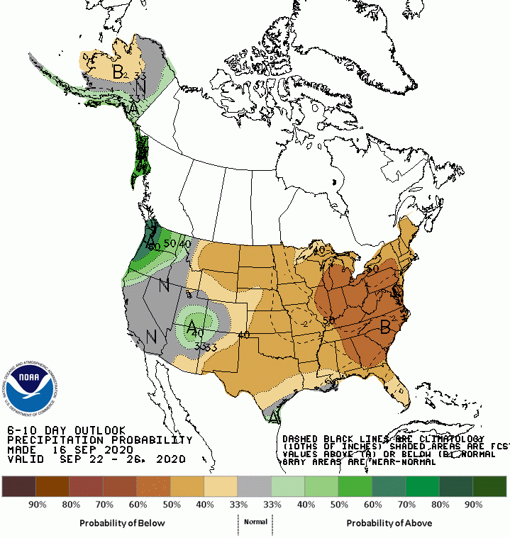
Outlooks continue to show cool and dry conditions for our area, even into the middle and end of next week. It does look like some moisture will be increasing for parts of the western US. Let’s hope that stays true for the folks dealing with wildfires!
Temperature

Precipitation

Weather Shot
I am a sucker for maps and this one is so very interesting! This map shows the number of flash flood warnings issued by county across the country from 2007 to 2019. I could analyze this all day!
I’ll point out a couple of things. First of all, notice the influence of the monsoon season across the Southwest US. When it rains it pours, right? Also notice that incredible concentration of warnings for the Lower Mississippi River Valley. That is fascinating. It is likely the result of tropical systems, as well as the meeting of cold fronts with Gulf moisture. I could analyze this all day…..

NASA Nerdology
Scientists just announced the sun is in a new cycle — meaning that we can expect to see solar activity start to ramp up over the next several years. Find out how these cycles are tracked and how they can affect life on Earth at https://go.nasa.gov/3hzt7G7. In the video below, imagine the scale of that solar “burst” of energy. It likely spans billions of miles. The size of space is overwhelming to our minds.
You all have a great day!
