Be sure to “Follow” the blog and get updates emailed straight to your inbox! Just find that “Follow” button in the lower right corner of your screen. Thank you!
Friday Funny

At a Glance
48-Hour Weather

Threats
A dry and stable air mass has moved in, preventing any storms from developing over the next seven days.
Baldwin’s Severe Weather Concern

Baldwin’s 7-Day forecast

Daily Forecast
Today: Gradually decreasing clouds. Breezy.
Saturday: Partly cloudy and pleasant.
Sunday – Thursday: Mostly sunny and quite pleasant.
Today’s Choice of Outdoor Activity

Hiking! With some clouds and cooler/drier air moving in, along with a bit of a breeze, it’s the perfect day for a hike or any outdoor activity! The same will be true for tomorrow. Be sure and check out some of the trails of the hiking marathon taking place this month in Cumberland County at https://hikingmarathon.com/!
Baldwin’s Hay Day Forecast
The fall hay weather forecast couldn’t possibly look any better! Be sure and take advantage of this great weather and get that fall hay in!

Almanac

Yesterday’s National High and Low Temperature
High: 116° at Winterhaven, California
Low: 22° at Grand Lake, Colorado
Tropics
The tropics continue to be very active, especially in the eastern Atlantic. The three yellow-shaded regions have low chances for development, but they’ll still be watched closely by the National Hurricane Center. The red-shaded region has a high chance for development and it will likely become a named storm within the next few days. That will more than likely be Alpha, as we’ll begin using the Greek alphabet.

The closest interest to the US is the depression in the southwest Gulf of Mexico. That will more than likely become Tropical Storm Wilfred by the end of the day. The track and intensity forecast for this system are both more uncertain than usual. The good news is that the system is in no hurry to get anywhere, so we have plenty of time to monitor it.

Hurricane Teddy is quite intense this morning, with 130 mph winds. The system is expected to pass extremely close to Bermuda Sunday night, possible bringing some very rough weather to the islands. The storm is then forecast to make an unusual turn westward toward Nova Scotia. While the storm will likely not have tropical characteristics when it hits Nova Scotia, it could still be packing winds of over 70 mph (or more)! This could be a very significant storm for Nova Scotia, with very severe impacts.

Today’s Wx Hazards Across the Nation
Unsettled weather can be found in the Pacific Northwest, where they desperately need some rain to fight wildfires. Unfortunately, that rain doesn’t quite make it into some parts of Nevada today and so the wildfire danger continues for the western and southern portions of that state. You’ll notice a developing tropical storm in the Gulf.

Tomorrow’s Wx Hazards Across the Nation
More rain is expected across portions of the Northwest, which is good news! Tropical Storm Wilfred continues to spin in the Gulf, with little movement expected from that system.

On This Day
1989 – Hurricane Hugo hit Puerto Rico, producing wind gusts to 92 mph at San Juan, and wind gusts to 120 mph at Roosevelt Roads. Hugo produced a storm surge of four to six feet, with northeastern sections of the island being deluged with more than ten inches of rain. Hugo claimed the lives of a dozen persons in Puerto Rico, and caused a billion dollars damage, including 100 million dollars damage to crops.
Long Range Outlook
By the end of next week, some moisture may be increasing along the Gulf Coast. That depends on what Wilfred does in the Gulf. That system could then swing our direction by next weekend, but that forecast is quite tricky. Otherwise, the pattern for the middle to end of next week features lots of dry weather for the country, with the exception of the Pacific Northwest, where they desperately need rain to fight wildfires. Unseasonably hot weather is expected across the northern plains, while we stay a bit cool.
Temperature

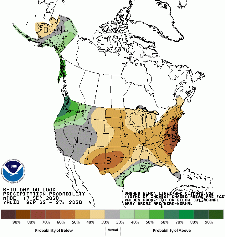
Precipitation
Weather Shot
Hurricane Hunter Garrett Black (@BLack22wx) posted last evening that, “Buoys were dropped within the black circle out in front of Hurricane Teddy. Should be interesting to see what data they bring in tomorrow as the storm passes overhead.” The different colors you see represent different winds speeds collected by the hunters. Hurricane Teddy strengthened into a powerful cat 4 hurricane last night, with winds of 140 mph. Look closely and you’ll see the eye of the storm near the middle of the picture. Notice the Hurricane Hunters flew right through it. Teddy remains a powerful cat 4 this morning.

NASA Nerdology
This is the crew of the next manned rocket launch to the International Space Station (ISS) from American soil. Remember Behnken and Hurley were the first two to launch back on May 30. Now, a second manned launch, this time with the four astronauts below, is planned for October 23rd. Astonauts Michael Hopkins, Victor Glover, and Shannon Walker of NASA and Soichi Noguchi of the Japan Aerospace Exploration Agency (JAXA) will launch to the ISS from Launch Complex 39A at NASA’s Kennedy Space Center in Florida.

You all have a great day!
