The Moon isn’t quite full yet, but it sure is close to it! Step out and take a look up if you can. Even before it’s even completely dark outside, it’s quite the sight to look up and see!
Just step out, look eastward, and then up. You can’t miss it.
Venus will also be very visible just after dark. It is the very bright evening star you see in the western sky.
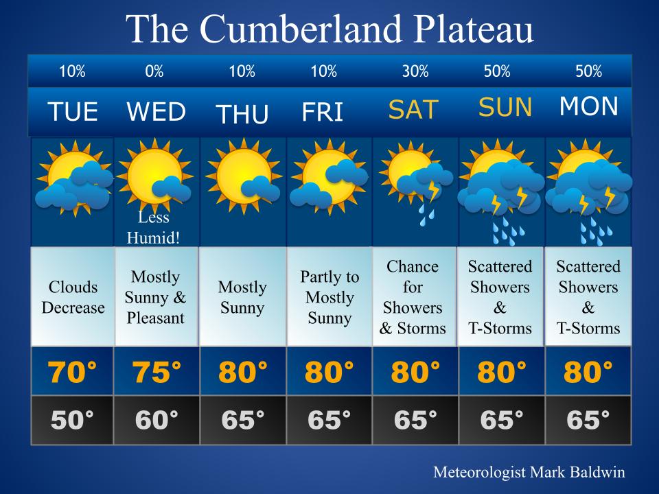
Today: Clouds decrease. Low humidity will make it feel quite nice!
Wednesday: Mostly sunny and very nice! Continued low humidity levels.
Thursday: Mostly sunny, but humidity increases a bit.
Friday: Partly to mostly sunny. Very warm.
Saturday: Partly to mostly sunny. A chance for mainly afternoon/evening showers or storms.
Sunday & Monday: Scattered showers and thunderstorms.
Hay Weather Forecast
Meteorologist Mark’s Wx Concerns
Almanac for Yesterday
Tropics
The National Hurricane Center is watching a system in the southern Atlantic. It has about a 30% chance for developing within the next 48 hours. After that, atmospheric conditions are expected to become unfavorable for the system. We’ll be tracking!
Sun & The Moon
Planting by the Moon in June
On This Day in Wx History
1947 – Twelve inches of rain fell in 42 minutes at Holt, Missouri, establishing a world rainfall record.
Yesterday’s National Temperature Extremes
High: 122° at Death Valley, California
Low: 28° at both West Yellowstone & White Sulphur Springs, Montana and at Albany, Wyoming
Twister Tuesday
With an average of more than 1,200 tornadoes annually, the U.S. leads with the most tornado activity in any country, according to NOAA’s National Centers for Environmental Information.
“Commonly in the spring and summer, including the winter occasionally, we get the winds that come off the Gulf of Mexico that provide ample moisture across much of the country,” Lavin said.
Ample moisture moving across the U.S., along with weather patterns causing winds to change, help provide the right ingredients for tornado occurrences, he added.
Today’s Tennessee Weather
Skies will clear from west to east, leaving the skies full of sunshine by afternoon for most. Low humidity, coupled with below average temperatures, will make for a very comfortable summer day!
Tonight’s Tennessee Weather
Under clear and starry skies, temperatures will drop into the 50s overnight. Temperatures on the Cumberland Plateau and upper East Tennessee will even drop to near 50 degrees! Low humidity will make for a very nice night!
Tomorrow’s Tennessee Weather
Sunshine and low humidity will make for another pleasant summer day across the state. Temperatures will be a bit warmer than on Tuesday, but it’s still a nice day for June!
Drought Monitor
The drought monitor is updated each Thursday.
Weather SnapShots
Twenty-four hours of daylight at the Arctic for the first full day of summer. Pretty cool, right?
NASA Nerdology
Paris at night, as seen from the International Space Station. Can I go up just to see this?
You all have a great day and keep lookin’ up!
Note: To offer support to Meteorologist Mark and his educational outreach programs, please consider giving via https://www.paypal.com/paypalme/meteorologistmark. If you can’t give, no worries! Just keep following and tell your friends!
A strong storm is moving into southwest Cumberland County at 2:40 pm. The trend this afternoon has been for storms to gradually become severe. As this storm moves across the county, be on the lookout for a damaging wind gust, hail, and torrential rainfall. Again, this storm is not severe at this time but it certainly could become severe at any moment.
Below is the current radar. The storm is coming into southwest Cumberland County and is moving northeast toward Crossville.
It is worth mentioning that a severe storm warning is in effect for Overton County at this hour. That storm could clip northern Fentress over the next 1-2 hours. Other strong storms can be found near Livingston and Clarkrange.
Be weather aware and have multiple ways to get warnings. Remember, I don’t issue warnings. Only the NWS can do that.
The Storm Prediction Center has just issued a severe thunderstorm watch for the northern half of Middle Tennessee until 8:00 pm this evening. While this does not include Cumberland County, I would just go ahead and assume it does, especially since our neighbors to the west and north are included.
The severe thunderstorm watch is shown below. These watches extend north to Pennsylvania. An active front, for sure!
Current radar shows showers and thunderstorms developing across the region. One step outside and you can feel the heat and humidity that will fuel our storms today!
The weather radio has been having some issues this morning. I contacted the NWS in Nashville and they have been working on the issue. Mine seems to be fine now. This just stresses the point that you should have multiple ways to get warnings!